IMAGES TAKEN NEAR TO
Upland Close, STURMINSTER NEWTON, DT10 2HL
Introduction
This page details the photographs taken nearby to Upland Close, DT10 2HL by members of the Geograph project.
The Geograph project started in 2005 with the aim of publishing, organising and preserving representative images for every square kilometre of Great Britain, Ireland and the Isle of Man.

There are currently over 7.5m images from over14,400 individuals and you can help contribute to the project by visiting https://www.geograph.org.uk
Image Map
Images are licensed for reuse under creativecommons.org/licenses/by-sa/2.0
Notes
- Clicking on the map will re-center to the selected point.
- The higher the marker number, the further away the image location is from the centre of the postcode.
Image Listing (6 Images Found)
Images are licensed for reuse under creativecommons.org/licenses/by-sa/2.0
Image
Details
Distance
1
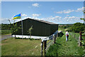
Flag, Barn & Footpath, Broad Oak
Heading westwards from Broad Oak.
Image: © Des Blenkinsopp
Taken: 7 May 2022
0.08 miles
2
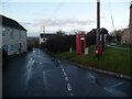
Broad Oak: postbox № DT10 72 and phone box
The postbox is emptied finally at 4pm on weekdays and at 9:30am on Saturdays.
Image: © Chris Downer
Taken: 24 Jan 2009
0.08 miles
3
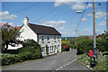
House in Broad Oak
The same view 15 years on from Image
The phone box has gone, a bit of rewiring, but otherwise not much change.
Image: © Des Blenkinsopp
Taken: 7 May 2022
0.08 miles
4
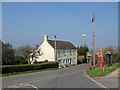
Broad Oak
Small village near Sturminster Newton.
Image: © Mike Searle
Taken: 27 Mar 2007
0.09 miles
5
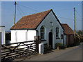
Primitive Methodist Chapel - Broad Oak
Built in 1869.
Image: © Mike Searle
Taken: 27 Mar 2007
0.12 miles
6
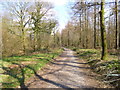
Broad Oak, bridleway
Through Piddles Wood to Fiddleford.
Image: © Mike Faherty
Taken: 3 Apr 2013
0.22 miles