IMAGES TAKEN NEAR TO
Sackmore Lane, STURMINSTER NEWTON, DT10 1PJ
Introduction
This page details the photographs taken nearby to Sackmore Lane, DT10 1PJ by members of the Geograph project.
The Geograph project started in 2005 with the aim of publishing, organising and preserving representative images for every square kilometre of Great Britain, Ireland and the Isle of Man.

There are currently over 7.5m images from over14,400 individuals and you can help contribute to the project by visiting https://www.geograph.org.uk
Image Map
Images are licensed for reuse under creativecommons.org/licenses/by-sa/2.0
Notes
- Clicking on the map will re-center to the selected point.
- The higher the marker number, the further away the image location is from the centre of the postcode.
Image Listing (16 Images Found)
Images are licensed for reuse under creativecommons.org/licenses/by-sa/2.0
Image
Details
Distance
1
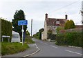
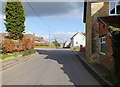
Sackmore Lane Marnhull
View north up Sackmore Lane. Taken from the southern end of the lane where Sackmore Lane, New St , Chippel Lane and Mounters meet at a crossroads.
Image: © Nigel Mykura
Taken: 18 Oct 2009
0.02 miles
2
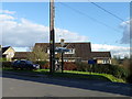
Finger Corner, Marnhull
The name of the junction may be related to a nearby house named Peters Finger.
Image: © Maigheach-gheal
Taken: 19 Feb 2012
0.06 miles
3
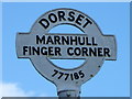
Sign, Finger Corner
The roundel from the Dorset County Council finger post shown in Image
Image: © Maigheach-gheal
Taken: 19 Feb 2012
0.06 miles
4
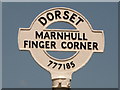
Marnhull: Finger Corner finger-post
The curious name for this junction may be connected with the house on the corner, immediately behind the camera, which is called Peter's Finger. The signpost, with original metal fingers, still retains its original Dorset finial, giving location ('Marnhull - Finger Corner') and six-digit grid reference.
Image: © Chris Downer
Taken: 18 Jul 2009
0.07 miles
5
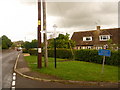
Marnhull: detail of Finger Corner finger-post
A close-up of the finial of the finger-post (see Image), giving location and grid reference details.
Image: © Chris Downer
Taken: 13 Jun 2010
0.07 miles
6
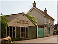
Marnhull: village shop and old radio shop
Alongside the village store is this olde worlde shopfront, formerly a radio, television and cycle shop.
Image: © Chris Downer
Taken: 13 Jun 2010
0.08 miles
7
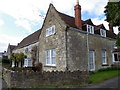
New Street
Looking along New Street past the junction with Fellowsmead on the left. Crosses House, closest to the camera on the right, has an Ordnance Survey benchmark on the farthest corner that can be seen in Image
Image: © Jonathan Kington
Taken: 19 Feb 2012
0.08 miles
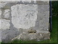
8
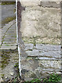
Benchmark, Crosses House
This very worn cut mark can be found on the corner of Crosses House, Image For more information visit http://www.bench-marks.org.uk/bm41520 .
Image: © Jonathan Kington
Taken: 19 Feb 2012
0.08 miles
9
Jessamine Cottages, New Street
There is an Ordnance Survey bench mark on the angle nearest the camera.
Image: © Maigheach-gheal
Taken: 19 Feb 2012
0.09 miles
10
Bench Mark, Jessamine Cottages
The Ordnance Survey bench mark is to be found on the southeast angle of the building. For a view of the building Image and for further information on the cut mark and others in the area http://www.bench-marks.org.uk/bm41524
Image: © Maigheach-gheal
Taken: 19 Feb 2012
0.09 miles