IMAGES TAKEN NEAR TO
Selwood Close, STURMINSTER NEWTON, DT10 1PE
Introduction
This page details the photographs taken nearby to Selwood Close, DT10 1PE by members of the Geograph project.
The Geograph project started in 2005 with the aim of publishing, organising and preserving representative images for every square kilometre of Great Britain, Ireland and the Isle of Man.

There are currently over 7.5m images from over14,400 individuals and you can help contribute to the project by visiting https://www.geograph.org.uk
Image Map (Loading...)


Getting Data...Please wait
Leaflet Map data © OpenStreetMap
Images are licensed for reuse under creativecommons.org/licenses/by-sa/2.0
Notes
- Clicking on the map will re-center to the selected point.
- The higher the marker number, the further away the image location is from the centre of the postcode.
Image Listing (7 Images Found)
Images are licensed for reuse under creativecommons.org/licenses/by-sa/2.0
Image
Details
Distance
1

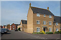
Apartment building on Field Close, Sturminster Newton
A new development on the north-east side of 'Stur'.
Image: © Jonathan Hutchins
Taken: 25 Nov 2017
0.08 miles
2
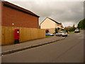
Sturminster Newton: postbox № DT10 32, Honeymead Lane
A modern box, emptied at 4:45pm on weekdays and at 9am on Saturdays.
Image: © Chris Downer
Taken: 18 Jul 2009
0.13 miles
3
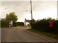
Sturminster Newton: postbox № DT10 153 and phone, Alder Road
The postbox is emptied at 4pm on weekdays and at 10am on Saturdays.
Image: © Chris Downer
Taken: 18 Jul 2009
0.19 miles
4
Honeymead Lane and Chivrick Close
Sturminster Newton is expanding northwards into this square.
Image: © Des Blenkinsopp
Taken: 9 May 2022
0.20 miles
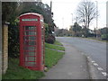
5
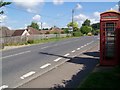
Telephone box, Sturminster Newton
K6 style telephone box beside the B3092.
Image: © Maigheach-gheal
Taken: 15 Jun 2009
0.24 miles
6
Sturminster Newton: phone box on Bath Road
A traditional red phone box on the northern outskirts of town.
Image: © Chris Downer
Taken: 16 Nov 2013
0.24 miles
7
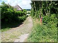
Footpath, Sturminster Newton
The footpath takes walkers from the B3092 towards Cutt Mill and the River Stour.
Image: © Maigheach-gheal
Taken: 15 Jun 2009
0.24 miles