IMAGES TAKEN NEAR TO
Nash Lane, STURMINSTER NEWTON, DT10 1JZ
Introduction
This page details the photographs taken nearby to Nash Lane, DT10 1JZ by members of the Geograph project.
The Geograph project started in 2005 with the aim of publishing, organising and preserving representative images for every square kilometre of Great Britain, Ireland and the Isle of Man.

There are currently over 7.5m images from over14,400 individuals and you can help contribute to the project by visiting https://www.geograph.org.uk
Image Map
Images are licensed for reuse under creativecommons.org/licenses/by-sa/2.0
Notes
- Clicking on the map will re-center to the selected point.
- The higher the marker number, the further away the image location is from the centre of the postcode.
Image Listing (5 Images Found)
Images are licensed for reuse under creativecommons.org/licenses/by-sa/2.0
Image
Details
Distance
1
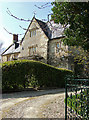
Nash Court - Marnhull
Nash Court is now predominantly 19th century in character but certainly originates from the 16th century when it was owned by the Abbey of Glastonbury. Subsequently acquired by Henry VIII at the time of the dissolution of the monasteries, it was then acquired by the Hussey family in whose hands it remained until 1884.
Image: © Mike Searle
Taken: 5 Apr 2007
0.02 miles
2
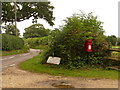
Marnhull: postbox № DT10 46, Hains Lane
This postbox serves northeastern Marnhull and is emptied finally at 4:15pm on weekdays and at 9:30 on Saturday mornings.
Image: © Chris Downer
Taken: 18 Jul 2009
0.09 miles
3
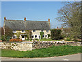
Nash Court Farmhouse - Marnhull
Grade II listed pair of cottages, now a single house. Probably constructed in two separate builds during the C17 and early C18.
Image: © Mike Searle
Taken: 5 Apr 2007
0.13 miles
5
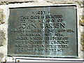
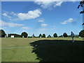
Commemoration to a public benefactor at the entrance to the recreation ground
Image: © Basher Eyre
Taken: 31 Aug 2013
0.25 miles