IMAGES TAKEN NEAR TO
Marnhull, STURMINSTER NEWTON, DT10 1HN
Introduction
This page details the photographs taken nearby to DT10 1HN by members of the Geograph project.
The Geograph project started in 2005 with the aim of publishing, organising and preserving representative images for every square kilometre of Great Britain, Ireland and the Isle of Man.

There are currently over 7.5m images from over14,400 individuals and you can help contribute to the project by visiting https://www.geograph.org.uk
Image Map (Loading...)


Getting Data...Please wait
Leaflet Map data © OpenStreetMap
Images are licensed for reuse under creativecommons.org/licenses/by-sa/2.0
Notes
- Clicking on the map will re-center to the selected point.
- The higher the marker number, the further away the image location is from the centre of the postcode.
Image Listing (6 Images Found)
Images are licensed for reuse under creativecommons.org/licenses/by-sa/2.0
Image
Details
Distance

4
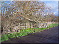
Towards Lymburghs Farm
From footpath N71 26, near its crossing of N71 27. The C17 farmhouse, glimpsed to the left of the oak's trunk, is described at https://www.historicengland.org.uk/listing/the-list/list-entry/1110399 .
Image: © Derek Harper
Taken: 26 May 2016
0.21 miles
5
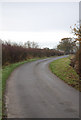
Path near Lymburghs Farm
Footpath N71 26 runs alongside a field boundary and past the end of another. View from the same spot as Image, looking in the opposite direction.
Image: © Derek Harper
Taken: 26 May 2016
0.24 miles
6
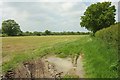
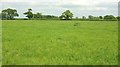
Field near Lymburghs Farm
Another view of the harvested field shown in Image
Image: © Derek Harper
Taken: 26 May 2016
0.25 miles