IMAGES TAKEN NEAR TO
Moorside, STURMINSTER NEWTON, DT10 1HH
Introduction
This page details the photographs taken nearby to DT10 1HH by members of the Geograph project.
The Geograph project started in 2005 with the aim of publishing, organising and preserving representative images for every square kilometre of Great Britain, Ireland and the Isle of Man.

There are currently over 7.5m images from over14,400 individuals and you can help contribute to the project by visiting https://www.geograph.org.uk
Image Map
Images are licensed for reuse under creativecommons.org/licenses/by-sa/2.0
Notes
- Clicking on the map will re-center to the selected point.
- The higher the marker number, the further away the image location is from the centre of the postcode.
Image Listing (2 Images Found)
Images are licensed for reuse under creativecommons.org/licenses/by-sa/2.0
Image
Details
Distance
1
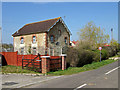
Former Chapel near Todber
South of Todber at the Hayes Farm turnoff is this converted chapel, no longer indicated as such on modern OS maps since its conversion to a private residence (although it is on my 1970s First Series 1:50,000 map).
Image: © Mike Searle
Taken: 5 Apr 2007
0.21 miles
2
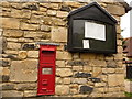
Todber: redundant Victorian postbox
Situated in the wall of the cottage which incorporated Todber Post Office till recently, this Victorian postbox has been replaced by a modern box a short distance north. Todber first had a post office in 1899 and it closed on 2 June 2008.
Image: © Chris Downer
Taken: 18 Jul 2009
0.22 miles