IMAGES TAKEN NEAR TO
Marnhull, STURMINSTER NEWTON, DT10 1FL
Introduction
This page details the photographs taken nearby to DT10 1FL by members of the Geograph project.
The Geograph project started in 2005 with the aim of publishing, organising and preserving representative images for every square kilometre of Great Britain, Ireland and the Isle of Man.

There are currently over 7.5m images from over14,400 individuals and you can help contribute to the project by visiting https://www.geograph.org.uk
Image Map
Images are licensed for reuse under creativecommons.org/licenses/by-sa/2.0
Notes
- Clicking on the map will re-center to the selected point.
- The higher the marker number, the further away the image location is from the centre of the postcode.
Image Listing (1 Images Found)
Images are licensed for reuse under creativecommons.org/licenses/by-sa/2.0
Image
Details
Distance
1
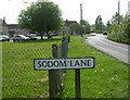
Marnhull, Sodom Lane
One wonders what used to go on for this road to receive its name; note also the (perhaps inevitable) graffito addition.
Image: © Mike Faherty
Taken: 23 Apr 2011
0.16 miles