IMAGES TAKEN NEAR TO
Torne View, DONCASTER, DN9 3PQ
Introduction
This page details the photographs taken nearby to Torne View, DN9 3PQ by members of the Geograph project.
The Geograph project started in 2005 with the aim of publishing, organising and preserving representative images for every square kilometre of Great Britain, Ireland and the Isle of Man.

There are currently over 7.5m images from over14,400 individuals and you can help contribute to the project by visiting https://www.geograph.org.uk
Image Map
Images are licensed for reuse under creativecommons.org/licenses/by-sa/2.0
Notes
- Clicking on the map will re-center to the selected point.
- The higher the marker number, the further away the image location is from the centre of the postcode.
Image Listing (17 Images Found)
Images are licensed for reuse under creativecommons.org/licenses/by-sa/2.0
Image
Details
Distance
3
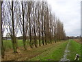
Poplar trees
This row of poplars stand between the River Torne and the recreation ground in Auckley.
Image: © steven ruffles
Taken: 29 Dec 2009
0.09 miles
5
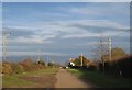
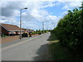
Common Lane, Auckley
Common Lane starts as a typical suburban village street but quickly becomes an unmetalled country lane. This is an intermediate stage.
Image: © Jonathan Thacker
Taken: 26 Nov 2011
0.17 miles
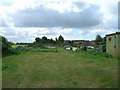
6
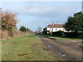
Common Lane, Auckley
Approaching Fortin Lodge Farm
Image: © Graham Hogg
Taken: 10 Jan 2017
0.19 miles

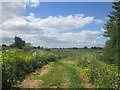
10
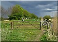
By The River Torne - near Kilham Farm
Image: © Neil Theasby
Taken: 30 Apr 2021
0.22 miles