IMAGES TAKEN NEAR TO
Ainsley Close, DONCASTER, DN9 3PG
Introduction
This page details the photographs taken nearby to Ainsley Close, DN9 3PG by members of the Geograph project.
The Geograph project started in 2005 with the aim of publishing, organising and preserving representative images for every square kilometre of Great Britain, Ireland and the Isle of Man.

There are currently over 7.5m images from over14,400 individuals and you can help contribute to the project by visiting https://www.geograph.org.uk
Image Map
Images are licensed for reuse under creativecommons.org/licenses/by-sa/2.0
Notes
- Clicking on the map will re-center to the selected point.
- The higher the marker number, the further away the image location is from the centre of the postcode.
Image Listing (18 Images Found)
Images are licensed for reuse under creativecommons.org/licenses/by-sa/2.0
Image
Details
Distance
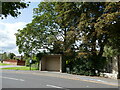
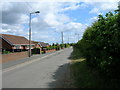
3
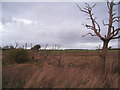
Dead trees
In waterlogged ground where Common Drain and Old Mill Dike meet.
Image: © Jonathan Thacker
Taken: 26 Nov 2011
0.13 miles
5
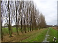
Poplar trees
This row of poplars stand between the River Torne and the recreation ground in Auckley.
Image: © steven ruffles
Taken: 29 Dec 2009
0.15 miles
8
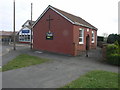
Church and Chips
Auckley Methodists Church and Auckley Friery stand side by side on Main Street.
Image: © Michael Patterson
Taken: 4 Apr 2007
0.16 miles
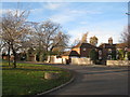
10
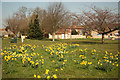
Auckley Green
Daffodils on the Green on Main Street
Image: © Richard Croft
Taken: 28 Mar 2012
0.17 miles