IMAGES TAKEN NEAR TO
Bank End Road, DONCASTER, DN9 3NT
Introduction
This page details the photographs taken nearby to Bank End Road, DN9 3NT by members of the Geograph project.
The Geograph project started in 2005 with the aim of publishing, organising and preserving representative images for every square kilometre of Great Britain, Ireland and the Isle of Man.

There are currently over 7.5m images from over14,400 individuals and you can help contribute to the project by visiting https://www.geograph.org.uk
Image Map
Images are licensed for reuse under creativecommons.org/licenses/by-sa/2.0
Notes
- Clicking on the map will re-center to the selected point.
- The higher the marker number, the further away the image location is from the centre of the postcode.
Image Listing (8 Images Found)
Images are licensed for reuse under creativecommons.org/licenses/by-sa/2.0
Image
Details
Distance
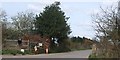
2
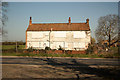
Old Bank End Farmhouse
Disused farmhouse on Bank End Road
Image: © Richard Croft
Taken: 28 Mar 2012
0.04 miles
3
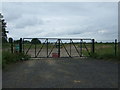
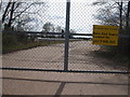
Entrance to CPCS site
CPCS is the Construction Plant Competence Scheme.
Image: © JThomas
Taken: 28 Jun 2014
0.06 miles
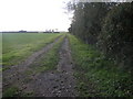
4

Farm track, Old Bank End Farm
Off Bank End Road.
Image: © JThomas
Taken: 28 Jun 2014
0.06 miles
5
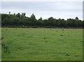
Corner Track
In the NE corner of this square this farm track runs by the side of woodland. The only other feature in this square being a railway line between Doncaster and Gainsborough.
Image: © Michael Patterson
Taken: 30 Oct 2006
0.16 miles
7
Farmland and woodland, Ash Holt
Off the B1396.
Image: © JThomas
Taken: 28 Jun 2014
0.20 miles
