IMAGES TAKEN NEAR TO
School Lane, DONCASTER, DN9 3JN
Introduction
This page details the photographs taken nearby to School Lane, DN9 3JN by members of the Geograph project.
The Geograph project started in 2005 with the aim of publishing, organising and preserving representative images for every square kilometre of Great Britain, Ireland and the Isle of Man.

There are currently over 7.5m images from over14,400 individuals and you can help contribute to the project by visiting https://www.geograph.org.uk
Image Map
Images are licensed for reuse under creativecommons.org/licenses/by-sa/2.0
Notes
- Clicking on the map will re-center to the selected point.
- The higher the marker number, the further away the image location is from the centre of the postcode.
Image Listing (14 Images Found)
Images are licensed for reuse under creativecommons.org/licenses/by-sa/2.0
Image
Details
Distance
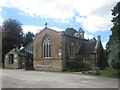
4
St Saviours in Auckley
St Saviours is busy on this morning in Holy Week. The church has been extended in a very modern way, but in keeping with the older building.
Image: © Michael Patterson
Taken: 4 Apr 2007
0.15 miles
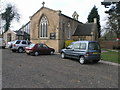
5
St Saviour's Church and Parish Centre, Auckley
Image: © John Slater
Taken: 3 Jun 2015
0.15 miles
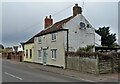
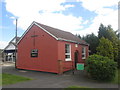
9
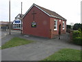
Church and Chips
Auckley Methodists Church and Auckley Friery stand side by side on Main Street.
Image: © Michael Patterson
Taken: 4 Apr 2007
0.23 miles