IMAGES TAKEN NEAR TO
Hazel Avenue, DONCASTER, DN9 3HE
Introduction
This page details the photographs taken nearby to Hazel Avenue, DN9 3HE by members of the Geograph project.
The Geograph project started in 2005 with the aim of publishing, organising and preserving representative images for every square kilometre of Great Britain, Ireland and the Isle of Man.

There are currently over 7.5m images from over14,400 individuals and you can help contribute to the project by visiting https://www.geograph.org.uk
Image Map
Images are licensed for reuse under creativecommons.org/licenses/by-sa/2.0
Notes
- Clicking on the map will re-center to the selected point.
- The higher the marker number, the further away the image location is from the centre of the postcode.
Image Listing (16 Images Found)
Images are licensed for reuse under creativecommons.org/licenses/by-sa/2.0
Image
Details
Distance
1
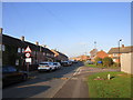
Sycamore Drive
Former RAF housing.
Image: © Jonathan Thacker
Taken: 17 Nov 2018
0.06 miles
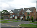
2
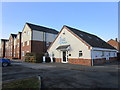
Hill Physio and new housing on Fir Tree Lane
Image: © Jonathan Thacker
Taken: 17 Nov 2018
0.09 miles
4
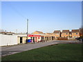
Convenience store and housing, Hayfield Green
Image: © Jonathan Thacker
Taken: 17 Nov 2018
0.10 miles
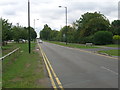
5
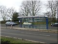
Bus stop and shelter at Hayfield School
An academy for students age 11-18.
Image: © Graham Hogg
Taken: 10 Jan 2017
0.11 miles
8
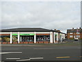
Co-operative Convenience Store, Hayfield Lane
Image: © Graham Hogg
Taken: 10 Jan 2017
0.14 miles
9
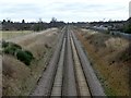
The Doncaster - Lincoln railway line
Looking east from the Hurst Lane road bridge
Image: © Graham Hogg
Taken: 10 Jan 2017
0.14 miles
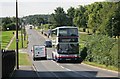
10
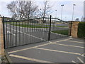
Hayfield at Easter
The gates of Hayfield School are closed for the Easter break.
Image: © Michael Patterson
Taken: 4 Apr 2007
0.17 miles