IMAGES TAKEN NEAR TO
Handley Court, DONCASTER, DN9 3GS
Introduction
This page details the photographs taken nearby to Handley Court, DN9 3GS by members of the Geograph project.
The Geograph project started in 2005 with the aim of publishing, organising and preserving representative images for every square kilometre of Great Britain, Ireland and the Isle of Man.

There are currently over 7.5m images from over14,400 individuals and you can help contribute to the project by visiting https://www.geograph.org.uk
Image Map
Images are licensed for reuse under creativecommons.org/licenses/by-sa/2.0
Notes
- Clicking on the map will re-center to the selected point.
- The higher the marker number, the further away the image location is from the centre of the postcode.
Image Listing (6 Images Found)
Images are licensed for reuse under creativecommons.org/licenses/by-sa/2.0
Image
Details
Distance
5
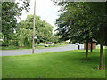
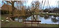
Finningley Green
A typical English village green with duckpond, bus shelter and (out of view) telephone kiosk.
Image: © Alan Murray-Rust
Taken: 22 Jul 2007
0.24 miles
6
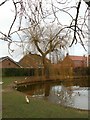
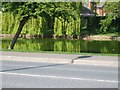
Winter tree by the duck pond
In Fillingley village
Image: © Graham Hogg
Taken: 10 Jan 2017
0.25 miles