IMAGES TAKEN NEAR TO
Manor Farm Court, DONCASTER, DN9 3FB
Introduction
This page details the photographs taken nearby to Manor Farm Court, DN9 3FB by members of the Geograph project.
The Geograph project started in 2005 with the aim of publishing, organising and preserving representative images for every square kilometre of Great Britain, Ireland and the Isle of Man.

There are currently over 7.5m images from over14,400 individuals and you can help contribute to the project by visiting https://www.geograph.org.uk
Image Map
Images are licensed for reuse under creativecommons.org/licenses/by-sa/2.0
Notes
- Clicking on the map will re-center to the selected point.
- The higher the marker number, the further away the image location is from the centre of the postcode.
Image Listing (33 Images Found)
Images are licensed for reuse under creativecommons.org/licenses/by-sa/2.0
Image
Details
Distance
1
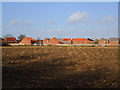
Expanding Finningley
Finningley has seen several new estates built in recent years. This is the latest.
Image: © Jonathan Thacker
Taken: 10 Jan 2015
0.08 miles
4
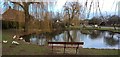
Finningley Green
A typical English village green with duckpond, bus shelter and (out of view) telephone kiosk.
Image: © Alan Murray-Rust
Taken: 22 Jul 2007
0.09 miles
5
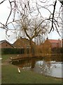
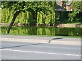
Winter tree by the duck pond
In Fillingley village
Image: © Graham Hogg
Taken: 10 Jan 2017
0.10 miles
6
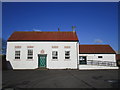
The Village Hall, Finningley
This building has a varied history. It began life as a barn, was converted to a school in 1839 and is now the Village Hall. http://www.britishlistedbuildings.co.uk/en-334764-the-village-hall-finningley-
Image: © Jonathan Thacker
Taken: 10 Jan 2015
0.12 miles
7
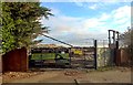
Demolition and remediation in progress at old works
What comes next, houses?
Image: © Chris Morgan
Taken: 10 Jan 2017
0.16 miles
8
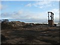
Demolition site in Finningley
The two large buildings shown on the OS map and on 2008 Google Earth imagery are no more.
Image: © Graham Hogg
Taken: 10 Jan 2017
0.17 miles
9
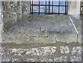
Ordnance Survey 1GL Bolt
This OS Bolt can be found on the north face of Holy Trinity Church. It marks a point 8.824m above mean sea level.
Image: © Adrian Dust
Taken: 24 May 2016
0.18 miles
10
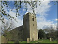
Holy Trinity and St Oswald's Church
Village church in Finningley.
Image: © steven ruffles
Taken: 26 Mar 2021
0.18 miles