IMAGES TAKEN NEAR TO
Wroot Road, DONCASTER, DN9 3DZ
Introduction
This page details the photographs taken nearby to Wroot Road, DN9 3DZ by members of the Geograph project.
The Geograph project started in 2005 with the aim of publishing, organising and preserving representative images for every square kilometre of Great Britain, Ireland and the Isle of Man.

There are currently over 7.5m images from over14,400 individuals and you can help contribute to the project by visiting https://www.geograph.org.uk
Image Map
Images are licensed for reuse under creativecommons.org/licenses/by-sa/2.0
Notes
- Clicking on the map will re-center to the selected point.
- The higher the marker number, the further away the image location is from the centre of the postcode.
Image Listing (22 Images Found)
Images are licensed for reuse under creativecommons.org/licenses/by-sa/2.0
Image
Details
Distance
1
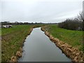
River Torne Soak Drain at Candy Farm
The river flows from Maltby in South Yorkshire to the River Trent at Keadby. Much of the river was engineered in the 17th century, as here, to drain Hatfield Chase.
Image: © Graham Hogg
Taken: 5 Jan 2018
0.03 miles
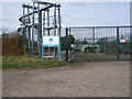
2
Candy Fen pumping station
And of course a Ford Ka.
Image: © Steve Fareham
Taken: 5 May 2008
0.04 miles
3
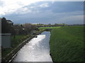
Godscross Drain at Candy Bridge
A short domesticated stretch.
Image: © Jonathan Thacker
Taken: 3 Apr 2011
0.04 miles

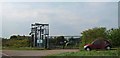
5
Candy Farm Pumping Station Nr Wroot Isle of Axholme North Lincolnshire
Wind powered pumping Station
Image: © Bob Pearce
Taken: 12 Aug 2017
0.05 miles
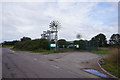
7
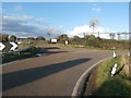
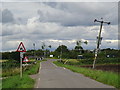
Farm Entrance and Pumping Station near Wroot
The road takes a sharp right here as it reaches the River Torne.
Image: © Jonathan Clitheroe
Taken: 17 Oct 2016
0.05 miles