IMAGES TAKEN NEAR TO
Old Bawtry Road, DONCASTER, DN9 3BY
Introduction
This page details the photographs taken nearby to Old Bawtry Road, DN9 3BY by members of the Geograph project.
The Geograph project started in 2005 with the aim of publishing, organising and preserving representative images for every square kilometre of Great Britain, Ireland and the Isle of Man.

There are currently over 7.5m images from over14,400 individuals and you can help contribute to the project by visiting https://www.geograph.org.uk
Image Map
Images are licensed for reuse under creativecommons.org/licenses/by-sa/2.0
Notes
- Clicking on the map will re-center to the selected point.
- The higher the marker number, the further away the image location is from the centre of the postcode.
Image Listing (34 Images Found)
Images are licensed for reuse under creativecommons.org/licenses/by-sa/2.0
Image
Details
Distance
2
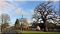
Bury Farm
Finningley has several green areas in the village but they are not linked together. This is the most southerly.
Image: © Jonathan Thacker
Taken: 10 Jan 2015
0.06 miles
3
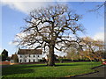
Old Bawtry Road in Finningley
The tree behind the weeping willow is a handsome old oak which looks in good shape and is still bearing acorns.
Image: © Jonathan Clitheroe
Taken: 5 Sep 2016
0.06 miles
4
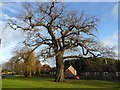
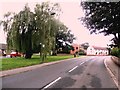
Winter tree in Finningley village
On a small grassed area off Old Bawtry Road
Image: © Graham Hogg
Taken: 10 Jan 2017
0.07 miles
5
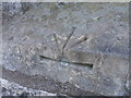
Ordnance Survey 1GL Bolt (Ref BT0976)
Holy Trinity and St. Oswald Church, Finningley.
Unusually the mark is upside down and cut in the vertical and sloping faces of the lower window sill.
Image: © Alan Barlow
Taken: 29 Nov 2013
0.08 miles
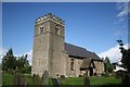
7
Holy Trinity church, Finningley
Norman tower and nave with a weatherworn south door, chancel c1300 with some late Early English / early Decorated tracery in the east window.
Image: © Richard Croft
Taken: 23 May 2006
0.08 miles
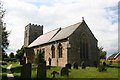
8
Holy Trinity & St Oswald's parish church, Finningley
Image: © Chris Morgan
Taken: 10 Jan 2017
0.08 miles
9
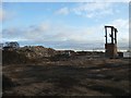
Demolition site in Finningley
The two large buildings shown on the OS map and on 2008 Google Earth imagery are no more.
Image: © Graham Hogg
Taken: 10 Jan 2017
0.09 miles
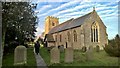
10
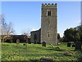
Holy Trinity church, Finningley
Norman west tower http://www.britishlistedbuildings.co.uk/en-334765-church-of-holy-trinity-and-st-oswald-fin
Image: © Jonathan Thacker
Taken: 10 Jan 2015
0.09 miles