IMAGES TAKEN NEAR TO
Honeysuckle Walk, DONCASTER, DN9 3BF
Introduction
This page details the photographs taken nearby to Honeysuckle Walk, DN9 3BF by members of the Geograph project.
The Geograph project started in 2005 with the aim of publishing, organising and preserving representative images for every square kilometre of Great Britain, Ireland and the Isle of Man.

There are currently over 7.5m images from over14,400 individuals and you can help contribute to the project by visiting https://www.geograph.org.uk
Image Map
Images are licensed for reuse under creativecommons.org/licenses/by-sa/2.0
Notes
- Clicking on the map will re-center to the selected point.
- The higher the marker number, the further away the image location is from the centre of the postcode.
Image Listing (7 Images Found)
Images are licensed for reuse under creativecommons.org/licenses/by-sa/2.0
Image
Details
Distance
2

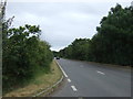
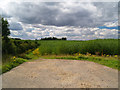
Hedgerow and crop field
West of Thorne Road.
Image: © JThomas
Taken: 28 Jun 2014
0.13 miles

5
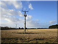
Electricity poles in a stubble field
Image: © Jonathan Thacker
Taken: 10 Jan 2015
0.21 miles
6
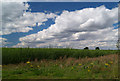
Willow for power station?
This looks like willow being grown for power generation. There is a new walk around this area.
Image: © Steve Fareham
Taken: 29 Jul 2007
0.23 miles
7
New concessionary walk.
Walk around crop of Willow, presumably for power generation.
Image: © Steve Fareham
Taken: 29 Jul 2007
0.25 miles