IMAGES TAKEN NEAR TO
New Street, DONCASTER, DN9 3AW
Introduction
This page details the photographs taken nearby to New Street, DN9 3AW by members of the Geograph project.
The Geograph project started in 2005 with the aim of publishing, organising and preserving representative images for every square kilometre of Great Britain, Ireland and the Isle of Man.

There are currently over 7.5m images from over14,400 individuals and you can help contribute to the project by visiting https://www.geograph.org.uk
Image Map
Images are licensed for reuse under creativecommons.org/licenses/by-sa/2.0
Notes
- Clicking on the map will re-center to the selected point.
- The higher the marker number, the further away the image location is from the centre of the postcode.
Image Listing (17 Images Found)
Images are licensed for reuse under creativecommons.org/licenses/by-sa/2.0
Image
Details
Distance

4
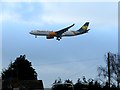
Flying over Blaxton
The aeroplane, an Airbus A330 G-VYGK operated by Thomas Cook, was doing flight training 'circuits and bumps'.
Image: © Graham Hogg
Taken: 10 Jan 2017
0.11 miles
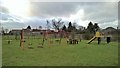
5
Blaxton recreation ground.
Quiet area
Image: © steven ruffles
Taken: 25 Mar 2010
0.13 miles


8
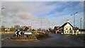
The Blue Bell at Blaxton
Looking towards Thorne Road on the A614
Image: © Chris Morgan
Taken: 10 Jan 2017
0.15 miles
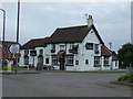
10
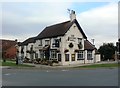
The Blue Bell Public House in Blaxton
Nicely presented village pub, both inside and out.
Image: © Jonathan Clitheroe
Taken: 5 Sep 2016
0.15 miles