IMAGES TAKEN NEAR TO
Back Lane, DONCASTER, DN9 3AJ
Introduction
This page details the photographs taken nearby to Back Lane, DN9 3AJ by members of the Geograph project.
The Geograph project started in 2005 with the aim of publishing, organising and preserving representative images for every square kilometre of Great Britain, Ireland and the Isle of Man.

There are currently over 7.5m images from over14,400 individuals and you can help contribute to the project by visiting https://www.geograph.org.uk
Image Map
Images are licensed for reuse under creativecommons.org/licenses/by-sa/2.0
Notes
- Clicking on the map will re-center to the selected point.
- The higher the marker number, the further away the image location is from the centre of the postcode.
Image Listing (17 Images Found)
Images are licensed for reuse under creativecommons.org/licenses/by-sa/2.0
Image
Details
Distance
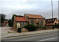
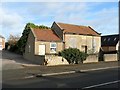
2
The old Wesleyan Chapel, Mosham Road, Blaxton
Image: © Bob Heron
Taken: 8 Sep 2009
0.04 miles
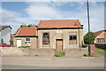
3
Former Wesleyan Chapel, Blaxton
This chapel dates back to 1838 and must have been thriving in 1960 when the extension was built. The original chapel may have been re-roofed and the walls rendered at about that time.
Image: © Chris Morgan
Taken: 10 Jan 2017
0.04 miles
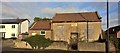
4
Former Wesleyan Chapel
Dating from 1834 with an extension in 1960 but now abandoned and becoming derelict.
Image: © Graham Hogg
Taken: 10 Jan 2017
0.04 miles
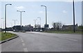
6
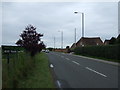
Mosham Road (B1396)
Heading west out of Blaxton.
Image: © JThomas
Taken: 28 Jun 2014
0.08 miles
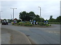
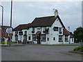
9
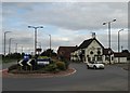
"The Bluebell Inn" and roundabout in Blaxton
Image: © Neil Theasby
Taken: 6 Sep 2016
0.13 miles