IMAGES TAKEN NEAR TO
Langholme Lane, DONCASTER, DN9 2NR
Introduction
This page details the photographs taken nearby to Langholme Lane, DN9 2NR by members of the Geograph project.
The Geograph project started in 2005 with the aim of publishing, organising and preserving representative images for every square kilometre of Great Britain, Ireland and the Isle of Man.

There are currently over 7.5m images from over14,400 individuals and you can help contribute to the project by visiting https://www.geograph.org.uk
Image Map
Images are licensed for reuse under creativecommons.org/licenses/by-sa/2.0
Notes
- Clicking on the map will re-center to the selected point.
- The higher the marker number, the further away the image location is from the centre of the postcode.
Image Listing (22 Images Found)
Images are licensed for reuse under creativecommons.org/licenses/by-sa/2.0
Image
Details
Distance
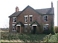
1
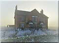
Farm cottages at Langholme Manor
Sadly abandoned long ago and now entering a state of dereliction.
Image: © Neil Theasby
Taken: 21 Jan 2023
0.01 miles
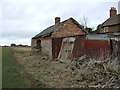
3
Abandoned cottages at Langholme Manor
Omce upon a time they housed farm workers and their families.
Image: © Neil Theasby
Taken: 21 Jan 2023
0.01 miles

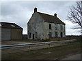
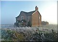
8
Sadly neglected farmhouse at Langholme Manor
Image: © Neil Theasby
Taken: 21 Jan 2023
0.05 miles
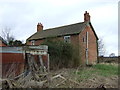
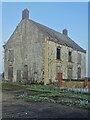
9
Empty House
The house at the farm is boarded up and has fallen into disrepair. However at the other side of the house there appears to be plenty of farming activity.
Image: © Michael Patterson
Taken: 4 Aug 2006
0.05 miles
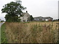
10
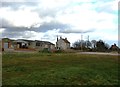
Langholme Manor
Farm on the River Idle flood plain to the south of Haxey. The county boundary between Nottinghamshire and Lincolnshire also runs through this picture; the derelict building on the far right is on the Lincolnshire side and is also situated in the adjoining grid square to the south - SK7596.
Image: © Jonathan Clitheroe
Taken: 22 Feb 2016
0.06 miles