IMAGES TAKEN NEAR TO
Marshgate, DONCASTER, DN5 8AF
Introduction
This page details the photographs taken nearby to Marshgate, DN5 8AF by members of the Geograph project.
The Geograph project started in 2005 with the aim of publishing, organising and preserving representative images for every square kilometre of Great Britain, Ireland and the Isle of Man.

There are currently over 7.5m images from over14,400 individuals and you can help contribute to the project by visiting https://www.geograph.org.uk
Image Map
Images are licensed for reuse under creativecommons.org/licenses/by-sa/2.0
Notes
- Clicking on the map will re-center to the selected point.
- The higher the marker number, the further away the image location is from the centre of the postcode.
Image Listing (124 Images Found)
Images are licensed for reuse under creativecommons.org/licenses/by-sa/2.0
Image
Details
Distance
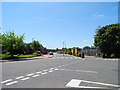
1
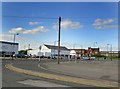
A neglected area of Town
The Marshgate area at the entrance to the prison is a neglected area since the new bridge opened and Dixon motors disappeared. On the right at weekends motor bikes used to gather at the motor bike shop, not sure if this still happens.
Image: © Steve Fareham
Taken: 15 May 2008
0.02 miles
2
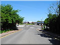
Elwis Street, Doncaster
Heading northeast towards Cherry Lane, Marsh Gate and North Bridge Road.
Image: © John Topping
Taken: 4 Jun 2013
0.02 miles
3

Elwis Street, Doncaster
Heading northwest.
Image: © John Topping
Taken: 4 Jun 2013
0.04 miles
4
River Cheswold, Doncaster
Viewed from Elwis Street Bridge.
Image: © John Topping
Taken: 4 Jun 2013
0.04 miles
5
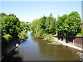
River Cheswold, Doncaster
View northwest from Elwis Street bridge. River Cheswold connecting River Don New Cut with the River Don.
Image: © John Topping
Taken: 4 Jun 2013
0.05 miles
6

Elwis Street, Doncaster
Heading northeast to Marsh Gate.
Image: © John Topping
Taken: 4 Jun 2013
0.07 miles
7
Entrance to HM Prison, Doncaster
At the junction of Elwis Street and Power Station Road (right).
Image: © John Topping
Taken: 4 Jun 2013
0.08 miles
8
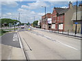
North Bridge Road, Doncaster
Looking out of town.
Image: © Nigel Thompson
Taken: 3 Jun 2013
0.09 miles
9

Power Station Road, Doncaster
Heading northwest from Elwis Street, towards Town End Industrial Estate.
Image: © John Topping
Taken: 4 Jun 2013
0.09 miles
10
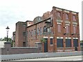
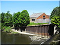
The Doncaster Warehouse
Presumably built as a warehouse, but now a nightclub (in fact, it claims to be 'The North's leading Underground dance venue'). The main entrance is from Marshgate at ground level; this view is from North Bridge Road at first floor level. The slightly art-deco keystones above the windows at this level suggest a 1920s/30s date; the building does appear on the 1940 OS map.
Image: © Stephen Craven
Taken: 23 Sep 2023
0.09 miles