IMAGES TAKEN NEAR TO
Green Lane, DONCASTER, DN5 7HR
Introduction
This page details the photographs taken nearby to Green Lane, DN5 7HR by members of the Geograph project.
The Geograph project started in 2005 with the aim of publishing, organising and preserving representative images for every square kilometre of Great Britain, Ireland and the Isle of Man.

There are currently over 7.5m images from over14,400 individuals and you can help contribute to the project by visiting https://www.geograph.org.uk
Image Map
Images are licensed for reuse under creativecommons.org/licenses/by-sa/2.0
Notes
- Clicking on the map will re-center to the selected point.
- The higher the marker number, the further away the image location is from the centre of the postcode.
Image Listing (5 Images Found)
Images are licensed for reuse under creativecommons.org/licenses/by-sa/2.0
Image
Details
Distance
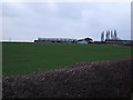
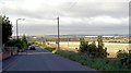
1
Ex Miners cottages.
Row of Terraced houses to the west of the Barnburgh colliery site.
Image: © steven ruffles
Taken: 3 Mar 2017
0.02 miles
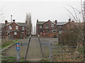
2
View across the Dearne Valley from what were the pit houses of Barnburgh colliery.
The colliery stood near here.
Image: © Steve Fareham
Taken: 15 Sep 2007
0.08 miles
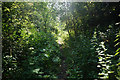
4
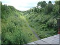
Railway cutting east of Goldthorpe
This railway cutting formerly carried the railway from Goldthorpe towards Harlington and beyond.
It is now a popular footpath - at least in dry weather; several puddles are visible in the distance in this view looking south-east from Green Lane.
Image: © David Wilkinson
Taken: 22 Jul 2007
0.16 miles