IMAGES TAKEN NEAR TO
Croft Road, DONCASTER, DN4 9HA
Introduction
This page details the photographs taken nearby to Croft Road, DN4 9HA by members of the Geograph project.
The Geograph project started in 2005 with the aim of publishing, organising and preserving representative images for every square kilometre of Great Britain, Ireland and the Isle of Man.

There are currently over 7.5m images from over14,400 individuals and you can help contribute to the project by visiting https://www.geograph.org.uk
Image Map
Images are licensed for reuse under creativecommons.org/licenses/by-sa/2.0
Notes
- Clicking on the map will re-center to the selected point.
- The higher the marker number, the further away the image location is from the centre of the postcode.
Image Listing (13 Images Found)
Images are licensed for reuse under creativecommons.org/licenses/by-sa/2.0
Image
Details
Distance
4
Millwood Road, Balby
Off The Broadway.
Image: © Richard Vince
Taken: 26 Jun 2021
0.16 miles
5
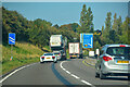
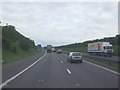
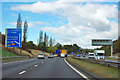
Warmsworth : A1(M)
Looking along the A1(M) heading northbound.
Image: © Lewis Clarke
Taken: 21 Sep 2020
0.16 miles
6
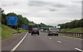
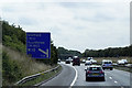
A1(M) 34 miles from Newark
Heading south, the M18 junction is one mile distant.
Image: © J.Hannan-Briggs
Taken: 15 Jun 2014
0.17 miles
9
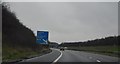
A1(M) - approaching junction 36
The yellow symbols on the sign are markers for potential diversionary routes.
Image: © Robin Webster
Taken: 7 Oct 2011
0.20 miles
10
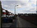
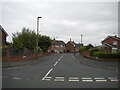
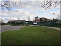
Cambria Drive
Suburban Doncaster.
Image: © Jonathan Thacker
Taken: 25 Mar 2018
0.22 miles