IMAGES TAKEN NEAR TO
Aldam Road, DONCASTER, DN4 9EA
Introduction
This page details the photographs taken nearby to Aldam Road, DN4 9EA by members of the Geograph project.
The Geograph project started in 2005 with the aim of publishing, organising and preserving representative images for every square kilometre of Great Britain, Ireland and the Isle of Man.

There are currently over 7.5m images from over14,400 individuals and you can help contribute to the project by visiting https://www.geograph.org.uk
Image Map
Images are licensed for reuse under creativecommons.org/licenses/by-sa/2.0
Notes
- Clicking on the map will re-center to the selected point.
- The higher the marker number, the further away the image location is from the centre of the postcode.
Image Listing (13 Images Found)
Images are licensed for reuse under creativecommons.org/licenses/by-sa/2.0
Image
Details
Distance
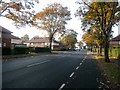
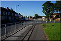
2
How do they water these plants?
Flower lined central reservations from A1M to Doncaster Town centre.
Image: © Steve Fareham
Taken: 16 Sep 2007
0.05 miles
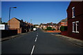
3
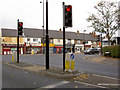
Warde Avenue junction
Junction with the Balby Road into Doncaster from Rotherham.
Image: © Steve Fareham
Taken: 16 Oct 2007
0.10 miles
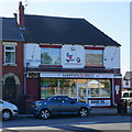
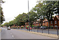
9
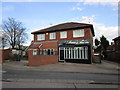
Selena's Hair Boutique
The adjacent premise also seems to have once been a shop.
Image: © Jonathan Thacker
Taken: 25 Mar 2018
0.21 miles
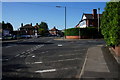
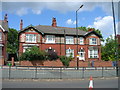
10
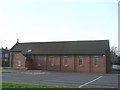
Sacred Heart Roman Catholic Church, Balby
Image: © Bill Henderson
Taken: 26 Jan 2007
0.22 miles