IMAGES TAKEN NEAR TO
Herons Way, DONCASTER, DN4 8WA
Introduction
This page details the photographs taken nearby to Herons Way, DN4 8WA by members of the Geograph project.
The Geograph project started in 2005 with the aim of publishing, organising and preserving representative images for every square kilometre of Great Britain, Ireland and the Isle of Man.

There are currently over 7.5m images from over14,400 individuals and you can help contribute to the project by visiting https://www.geograph.org.uk
Image Map
Images are licensed for reuse under creativecommons.org/licenses/by-sa/2.0
Notes
- Clicking on the map will re-center to the selected point.
- The higher the marker number, the further away the image location is from the centre of the postcode.
Image Listing (8 Images Found)
Images are licensed for reuse under creativecommons.org/licenses/by-sa/2.0
Image
Details
Distance
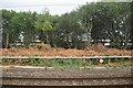
3
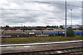
Class 56 Diesels
Awaiting their fate in the sidings, some of this class were built at Doncaster.
http://en.wikipedia.org/wiki/British_Rail_Class_56
Image: © Ashley Dace
Taken: 11 Aug 2010
0.22 miles
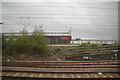
6
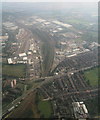
Railport and A18-A630 roundabout, Doncaster: aerial 2014
Image: © Chris
Taken: 10 Sep 2014
0.24 miles
8
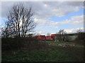
Stacked containers and fly-tipped waste
Fly-tipping seems to be endemic in Doncaster.
Image: © Jonathan Thacker
Taken: 25 Mar 2018
0.25 miles