IMAGES TAKEN NEAR TO
Weston Road, DONCASTER, DN4 8JS
Introduction
This page details the photographs taken nearby to Weston Road, DN4 8JS by members of the Geograph project.
The Geograph project started in 2005 with the aim of publishing, organising and preserving representative images for every square kilometre of Great Britain, Ireland and the Isle of Man.

There are currently over 7.5m images from over14,400 individuals and you can help contribute to the project by visiting https://www.geograph.org.uk
Image Map
Images are licensed for reuse under creativecommons.org/licenses/by-sa/2.0
Notes
- Clicking on the map will re-center to the selected point.
- The higher the marker number, the further away the image location is from the centre of the postcode.
Image Listing (11 Images Found)
Images are licensed for reuse under creativecommons.org/licenses/by-sa/2.0
Image
Details
Distance
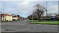
4
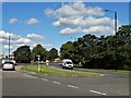
Road junction in Balby
Where the A60 Tickhill Road meets Weston Road.
Image: © Neil Theasby
Taken: 19 Sep 2017
0.13 miles
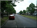
5
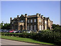
St.Catherine's Hospital
Regency Gothick main administrative building on the St.Catherine's hospital site, now the headquarters of 'Rotherham Doncaster and South Humber NHS Trust'. Built in 1839 by John Clark of Leeds as a country house for industrialist George Books.
Image: © Richard Croft
Taken: 12 Sep 2005
0.13 miles
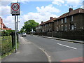
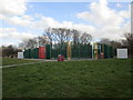
8
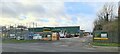
Travis Perkins, Timber and Builders Merchants
Image: © Chris Morgan
Taken: 13 Jan 2023
0.18 miles
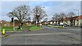
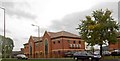
9
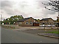
Woodfield Social and Recreational Club
Woodfield Road Doncaster.
Image: © Steve Fareham
Taken: 15 Oct 2008
0.21 miles