IMAGES TAKEN NEAR TO
Surrey Street, DONCASTER, DN4 8HZ
Introduction
This page details the photographs taken nearby to Surrey Street, DN4 8HZ by members of the Geograph project.
The Geograph project started in 2005 with the aim of publishing, organising and preserving representative images for every square kilometre of Great Britain, Ireland and the Isle of Man.

There are currently over 7.5m images from over14,400 individuals and you can help contribute to the project by visiting https://www.geograph.org.uk
Image Map
Images are licensed for reuse under creativecommons.org/licenses/by-sa/2.0
Notes
- Clicking on the map will re-center to the selected point.
- The higher the marker number, the further away the image location is from the centre of the postcode.
Image Listing (11 Images Found)
Images are licensed for reuse under creativecommons.org/licenses/by-sa/2.0
Image
Details
Distance
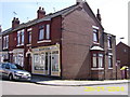
2
Woodfield Social and Recreational Club
Woodfield Road Doncaster.
Image: © Steve Fareham
Taken: 15 Oct 2008
0.15 miles
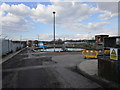
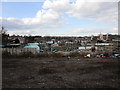
7
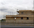
Yet more apartments.
New apartments being built adjacent to the A630.
Image: © Steve Fareham
Taken: 16 Sep 2007
0.22 miles