IMAGES TAKEN NEAR TO
Bawtry Road, DONCASTER, DN4 7PB
Introduction
This page details the photographs taken nearby to Bawtry Road, DN4 7PB by members of the Geograph project.
The Geograph project started in 2005 with the aim of publishing, organising and preserving representative images for every square kilometre of Great Britain, Ireland and the Isle of Man.

There are currently over 7.5m images from over14,400 individuals and you can help contribute to the project by visiting https://www.geograph.org.uk
Image Map (Loading...)


Getting Data...Please wait
Leaflet Map data © OpenStreetMap
Images are licensed for reuse under creativecommons.org/licenses/by-sa/2.0
Notes
- Clicking on the map will re-center to the selected point.
- The higher the marker number, the further away the image location is from the centre of the postcode.
Image Listing (15 Images Found)
Images are licensed for reuse under creativecommons.org/licenses/by-sa/2.0
Image
Details
Distance
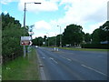
3
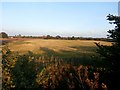
Field near Rossington Bridge
Looking east from the A638 roadside. I'd just been accosted by a weather-beaten man who was heading on foot to Robin Hood Airport en route to Latvia.
Image: © Jonathan Clitheroe
Taken: 15 Oct 2016
0.08 miles

7
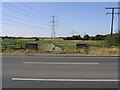
Rossington Bridge
Rossington Bridge carries the A638 over the River Torne.
Image: © Michael Patterson
Taken: 24 Jul 2006
0.12 miles
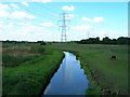
8
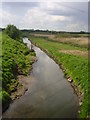
River Torne from Rossington bridge
A Roman fort was situated on this site.
Image: © steven ruffles
Taken: 11 May 2010
0.13 miles
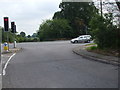
9
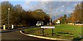
Junction with Warning Tongue Lane and the A638
Image: © Steve Fareham
Taken: 27 Nov 2008
0.13 miles
10
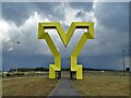
"Y" is for Yorkshire
Huge yellow "Y" at the Doncaster "Park and Ride" near the new link road to Robin Hood Airport. The new road is known as "The Great Yorkshire Way".
Image: © Neil Theasby
Taken: 30 Apr 2021
0.18 miles