IMAGES TAKEN NEAR TO
Stayers Road, DONCASTER, DN4 7FJ
Introduction
This page details the photographs taken nearby to Stayers Road, DN4 7FJ by members of the Geograph project.
The Geograph project started in 2005 with the aim of publishing, organising and preserving representative images for every square kilometre of Great Britain, Ireland and the Isle of Man.

There are currently over 7.5m images from over14,400 individuals and you can help contribute to the project by visiting https://www.geograph.org.uk
Image Map
Images are licensed for reuse under creativecommons.org/licenses/by-sa/2.0
Notes
- Clicking on the map will re-center to the selected point.
- The higher the marker number, the further away the image location is from the centre of the postcode.
Image Listing (20 Images Found)
Images are licensed for reuse under creativecommons.org/licenses/by-sa/2.0
Image
Details
Distance
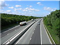
3
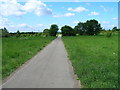
Warren Lane
Running parallel with the M18.
Image: © Jonathan Thacker
Taken: 24 May 2014
0.14 miles
4
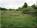
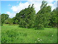
Vestiges of lost buildings
Was this once a farm?
Image: © Jonathan Thacker
Taken: 24 May 2014
0.14 miles

8
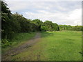
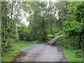
Bessacarr Lane
Just a partly metalled track.
Image: © Jonathan Thacker
Taken: 24 May 2014
0.16 miles
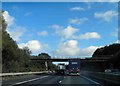
9
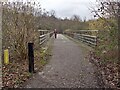
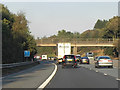
Motorway footbridge
Over the M18 near Rossington
Image: © Graham Hogg
Taken: 13 Jan 2023
0.16 miles