IMAGES TAKEN NEAR TO
Bawtry Road, DONCASTER, DN4 7DA
Introduction
This page details the photographs taken nearby to Bawtry Road, DN4 7DA by members of the Geograph project.
The Geograph project started in 2005 with the aim of publishing, organising and preserving representative images for every square kilometre of Great Britain, Ireland and the Isle of Man.

There are currently over 7.5m images from over14,400 individuals and you can help contribute to the project by visiting https://www.geograph.org.uk
Image Map
Images are licensed for reuse under creativecommons.org/licenses/by-sa/2.0
Notes
- Clicking on the map will re-center to the selected point.
- The higher the marker number, the further away the image location is from the centre of the postcode.
Image Listing (14 Images Found)
Images are licensed for reuse under creativecommons.org/licenses/by-sa/2.0
Image
Details
Distance
1
Bessacarr Lane
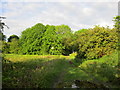
A gas valve compound is hidden behind the trees.
Image: © Jonathan Thacker
Taken: 24 May 2014
0.10 miles
3
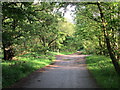
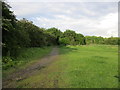
Doncaster Greenway
Looking towards Rossington. The Greenway crosses an area of carr which though once drained has been allowed to revert to something like its natural condition.
Image: © Jonathan Thacker
Taken: 24 May 2014
0.12 miles
4
Warren Lane
Close to the junction with Bessacarr Lane
Image: © Jonathan Thacker
Taken: 24 May 2014
0.13 miles
5
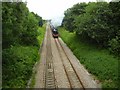
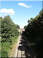
8f 'Gauge O Guild' 48151 outside Doncaster
The 8f on a tour to Cleethorpes on the little used bridge outside Doncaster.
It is travelling at 35 mph which now, after new rules, is its top speed permitted due to its small wheels.
Image: © Ashley Dace
Taken: Unknown
0.13 miles
6
Bessacarr Lane
Just a partly metalled track.
Image: © Jonathan Thacker
Taken: 24 May 2014
0.15 miles
7
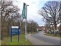
Flags and signs on Cammidge Way
The approach road to the Warren Park housing development
Image: © Graham Hogg
Taken: 13 Jan 2023
0.18 miles
8
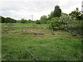
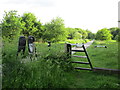
Vestiges of lost buildings
Was this once a farm?
Image: © Jonathan Thacker
Taken: 24 May 2014
0.21 miles
9
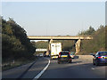
M18 Northbound, Bawtry Road Bridge
The A638, Bawtry Road, crossing the northbound M18 to the east of Doncaster. The rail bridge is visible behind the road bridge.
Image: © David Dixon
Taken: 14 Oct 2011
0.22 miles
10
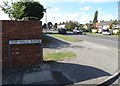
Top Hall Road's junction with Bawtry Road
Image: © Neil Theasby
Taken: 9 Aug 2014
0.23 miles