IMAGES TAKEN NEAR TO
Cantley Lane, DONCASTER, DN4 6NE
Introduction
This page details the photographs taken nearby to Cantley Lane, DN4 6NE by members of the Geograph project.
The Geograph project started in 2005 with the aim of publishing, organising and preserving representative images for every square kilometre of Great Britain, Ireland and the Isle of Man.

There are currently over 7.5m images from over14,400 individuals and you can help contribute to the project by visiting https://www.geograph.org.uk
Image Map (Loading...)


Getting Data...Please wait
Leaflet Map data © OpenStreetMap
Images are licensed for reuse under creativecommons.org/licenses/by-sa/2.0
Notes
- Clicking on the map will re-center to the selected point.
- The higher the marker number, the further away the image location is from the centre of the postcode.
Image Listing (12 Images Found)
Images are licensed for reuse under creativecommons.org/licenses/by-sa/2.0
Image
Details
Distance

4
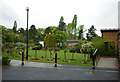
Rose Hill Crematorium
A well kept and tasteful entrance to the Rose Hill Crematorium off Cantley Lane in the Bessacarr area of Doncaster
Image: © David Ward
Taken: 28 Jul 2007
0.10 miles
5
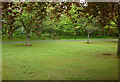
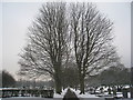
Central Avenue, Rose Hill Cemetery
There are several avenues each planted with a different type of tree.
Image: © Jonathan Thacker
Taken: 22 Jan 2013
0.12 miles
6
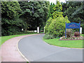
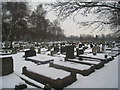
Avenue, Rose Hill Cemetery
There are several avenues each planted with a different type of tree.
Image: © Jonathan Thacker
Taken: 22 Jan 2013
0.14 miles
10
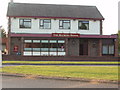
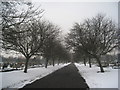
The Bechers Brook Public House, New Cantley
Image: © Robert Neilson
Taken: 2 May 2007
0.19 miles