IMAGES TAKEN NEAR TO
Cantley Lane, DONCASTER, DN4 6NA
Introduction
This page details the photographs taken nearby to Cantley Lane, DN4 6NA by members of the Geograph project.
The Geograph project started in 2005 with the aim of publishing, organising and preserving representative images for every square kilometre of Great Britain, Ireland and the Isle of Man.

There are currently over 7.5m images from over14,400 individuals and you can help contribute to the project by visiting https://www.geograph.org.uk
Image Map (Loading...)


Getting Data...Please wait
Leaflet Map data © OpenStreetMap
Images are licensed for reuse under creativecommons.org/licenses/by-sa/2.0
Notes
- Clicking on the map will re-center to the selected point.
- The higher the marker number, the further away the image location is from the centre of the postcode.
Image Listing (8 Images Found)
Images are licensed for reuse under creativecommons.org/licenses/by-sa/2.0
Image
Details
Distance
1

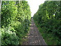
Freight line from Cantley Bridge
Single track freight line seen from Cantley Bridge
Image: © Richard Croft
Taken: 28 Mar 2012
0.05 miles
3
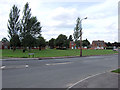
Doncaster - Ascot Avenue
A very attractive green open space setting off the southern end of Ascot Avenue where it leads off Cantley Lane
Image: © David Ward
Taken: 28 Jul 2007
0.11 miles
4
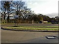
Car park to Rose Hill cemetery
Complete with rubbish dump, not the best setting in the world.
Image: © Steve Fareham
Taken: 27 Nov 2008
0.15 miles
5
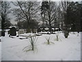
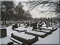
Their first winter?
Yuccas in Rose Hill Cemetery.
Image: © Jonathan Thacker
Taken: 22 Jan 2013
0.16 miles
7
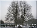
Avenue, Rose Hill Cemetery
There are several avenues each planted with a different type of tree.
Image: © Jonathan Thacker
Taken: 22 Jan 2013
0.23 miles