IMAGES TAKEN NEAR TO
Palington Grove, DONCASTER, DN4 6LP
Introduction
This page details the photographs taken nearby to Palington Grove, DN4 6LP by members of the Geograph project.
The Geograph project started in 2005 with the aim of publishing, organising and preserving representative images for every square kilometre of Great Britain, Ireland and the Isle of Man.

There are currently over 7.5m images from over14,400 individuals and you can help contribute to the project by visiting https://www.geograph.org.uk
Image Map (Loading...)


Getting Data...Please wait
Leaflet Map data © OpenStreetMap
Images are licensed for reuse under creativecommons.org/licenses/by-sa/2.0
Notes
- Clicking on the map will re-center to the selected point.
- The higher the marker number, the further away the image location is from the centre of the postcode.
Image Listing (7 Images Found)
Images are licensed for reuse under creativecommons.org/licenses/by-sa/2.0
Image
Details
Distance
1
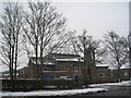
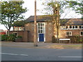
St. Hugh of Lincoln, New Cantley
The parish church for a large estate developed in the 1950s and 60s.
Image: © Jonathan Thacker
Taken: 22 Jan 2013
0.06 miles
2
Church of Hugh of Lincoln, New Cantley
Image: © Robert Neilson
Taken: 2 May 2007
0.08 miles
3
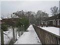
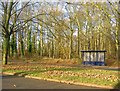
Path to Ansten Crescent
The crescent of houses surrounds a small area of birch trees which can be seen at the end of the path.
Image: © Jonathan Thacker
Taken: 22 Jan 2013
0.09 miles
4
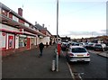
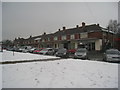
Post Office, Shops and Public House in Cantley
Situated on Everingham Road.
Image: © Jonathan Clitheroe
Taken: 5 Nov 2016
0.13 miles