IMAGES TAKEN NEAR TO
Tranmoor Avenue, DONCASTER, DN4 6DL
Introduction
This page details the photographs taken nearby to Tranmoor Avenue, DN4 6DL by members of the Geograph project.
The Geograph project started in 2005 with the aim of publishing, organising and preserving representative images for every square kilometre of Great Britain, Ireland and the Isle of Man.

There are currently over 7.5m images from over14,400 individuals and you can help contribute to the project by visiting https://www.geograph.org.uk
Image Map
Images are licensed for reuse under creativecommons.org/licenses/by-sa/2.0
Notes
- Clicking on the map will re-center to the selected point.
- The higher the marker number, the further away the image location is from the centre of the postcode.
Image Listing (6 Images Found)
Images are licensed for reuse under creativecommons.org/licenses/by-sa/2.0
Image
Details
Distance
1
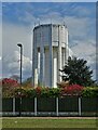
The taller of the two water towers at Cantley
This landmark is visible for miles around
Image: © Neil Theasby
Taken: 30 Apr 2021
0.07 miles

4
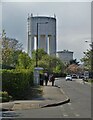
On Goodison Boulevard
Approaching Cantley Water Towers
Image: © Neil Theasby
Taken: 30 Apr 2021
0.23 miles
5
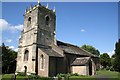
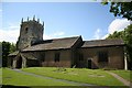
St.Wilfrid's church, Cantley
Norman origins, some 13th century lancet windows, Decorated south arcade and Perpendicular tower. Some restoration by Sir Ninian Comper in 1892-4.
Image: © Richard Croft
Taken: 23 May 2006
0.24 miles