IMAGES TAKEN NEAR TO
Highbury Avenue, DONCASTER, DN4 6AW
Introduction
This page details the photographs taken nearby to Highbury Avenue, DN4 6AW by members of the Geograph project.
The Geograph project started in 2005 with the aim of publishing, organising and preserving representative images for every square kilometre of Great Britain, Ireland and the Isle of Man.

There are currently over 7.5m images from over14,400 individuals and you can help contribute to the project by visiting https://www.geograph.org.uk
Image Map
Images are licensed for reuse under creativecommons.org/licenses/by-sa/2.0
Notes
- Clicking on the map will re-center to the selected point.
- The higher the marker number, the further away the image location is from the centre of the postcode.
Image Listing (7 Images Found)
Images are licensed for reuse under creativecommons.org/licenses/by-sa/2.0
Image
Details
Distance

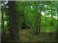
4
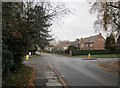
Path to Ansten Crescent
The crescent of houses surrounds a small area of birch trees which can be seen at the end of the path.
Image: © Jonathan Thacker
Taken: 22 Jan 2013
0.23 miles
6
Whin Hill Road crossing St. Wilfred's Road
Photograph taken on Whin Hill Road.
Image: © Jonathan Thacker
Taken: 27 Nov 2018
0.23 miles