IMAGES TAKEN NEAR TO
Princes Road, DONCASTER, DN4 5LW
Introduction
This page details the photographs taken nearby to Princes Road, DN4 5LW by members of the Geograph project.
The Geograph project started in 2005 with the aim of publishing, organising and preserving representative images for every square kilometre of Great Britain, Ireland and the Isle of Man.

There are currently over 7.5m images from over14,400 individuals and you can help contribute to the project by visiting https://www.geograph.org.uk
Image Map (Loading...)


Getting Data...Please wait
Leaflet Map data © OpenStreetMap
Images are licensed for reuse under creativecommons.org/licenses/by-sa/2.0
Notes
- Clicking on the map will re-center to the selected point.
- The higher the marker number, the further away the image location is from the centre of the postcode.
Image Listing (5 Images Found)
Images are licensed for reuse under creativecommons.org/licenses/by-sa/2.0
Image
Details
Distance
2
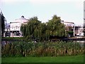
The Dome Leisure Centre, Doncaster
Modern leisure centre with all the usual facilities, plus lake with wildlife & pleasant grounds. It is also a venue for conferences, exhibitions and concerts.
Image: © Lynne Kirton
Taken: 16 Oct 2005
0.19 miles
3
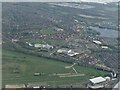
Across Doncaster Racecourse to site of former Doncaster Airfield: aerial 2022
A thriving airfield destroyed to make way for some houses and a pond.
Image: © Simon Tomson
Taken: 17 Apr 2022
0.21 miles
4
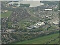
Across Doncaster Dome to the site of former Doncaster Airfield: aerial 2022
Image: © Simon Tomson
Taken: 17 Apr 2022
0.23 miles