IMAGES TAKEN NEAR TO
St. Hildas Road, DONCASTER, DN4 5EE
Introduction
This page details the photographs taken nearby to St. Hildas Road, DN4 5EE by members of the Geograph project.
The Geograph project started in 2005 with the aim of publishing, organising and preserving representative images for every square kilometre of Great Britain, Ireland and the Isle of Man.

There are currently over 7.5m images from over14,400 individuals and you can help contribute to the project by visiting https://www.geograph.org.uk
Image Map
Images are licensed for reuse under creativecommons.org/licenses/by-sa/2.0
Notes
- Clicking on the map will re-center to the selected point.
- The higher the marker number, the further away the image location is from the centre of the postcode.
Image Listing (19 Images Found)
Images are licensed for reuse under creativecommons.org/licenses/by-sa/2.0
Image
Details
Distance
1
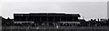
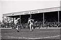
The Town End at Belle Vue
Doncaster Rovers played at Belle Vue from 1922 until 2006.
Image: © Steve Daniels
Taken: 16 Apr 1983
0.11 miles
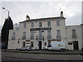
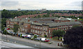
3
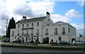
The Grand St. Leger Hotel
One of Doncaster's grandest houses built for its position adjacent to the racecourse. Now a hotel. http://www.britishlistedbuildings.co.uk/en-334999-the-grand-st-leger-hotel-with-flanking-s
Image: © Jonathan Thacker
Taken: 22 Jan 2013
0.13 miles
4
The Grand St Leger hotel.
Bennethorpe, Doncaster.
Image: © steven ruffles
Taken: 18 Jan 2021
0.15 miles
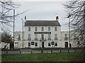
5
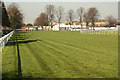
The Main Stand at Belle Vue
Doncaster Rovers played at Belle Vue from 1922 until 2006.
Image: © Steve Daniels
Taken: 16 Apr 1983
0.16 miles
6
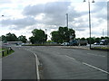
South Parade, Doncaster approaching roundabout
Image: © JThomas
Taken: 24 May 2011
0.16 miles
8
Doncaster Racecourse
The first bend at Doncaster Racecourse, seen from Tan Crossing
Image: © Richard Croft
Taken: 28 Mar 2012
0.17 miles
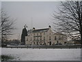
9
Doncaster College for the Deaf
View of the College from Doncaster Racecourse grandstand on the other side of the A18 Leger Way road. There is a playing field to the rear and other College buildings to the right
Image: © John Chamberlain
Taken: 7 Jul 2006
0.17 miles
10
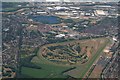
Doncaster Racecourse and site of Doncaster Airfield: aerial 2018
See also Image] and Image
Airfield site includes the pond, road and housing estate. Doncaster Council closed the thriving airfield in 1992.
History of this iconic little airfield can be found at www.ukga.com/airfield/doncaster
Image: © Chris
Taken: 2 Jul 2018
0.18 miles