IMAGES TAKEN NEAR TO
Stockil Road, DONCASTER, DN4 5AT
Introduction
This page details the photographs taken nearby to Stockil Road, DN4 5AT by members of the Geograph project.
The Geograph project started in 2005 with the aim of publishing, organising and preserving representative images for every square kilometre of Great Britain, Ireland and the Isle of Man.

There are currently over 7.5m images from over14,400 individuals and you can help contribute to the project by visiting https://www.geograph.org.uk
Image Map
Images are licensed for reuse under creativecommons.org/licenses/by-sa/2.0
Notes
- Clicking on the map will re-center to the selected point.
- The higher the marker number, the further away the image location is from the centre of the postcode.
Image Listing (8 Images Found)
Images are licensed for reuse under creativecommons.org/licenses/by-sa/2.0
Image
Details
Distance
1
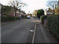
Chequer Avenue in Doncaster
Near the corner of Hamilton Road on Chequer Avenue in Hyde Park.
Image: © Andrea Hope
Taken: 18 Nov 2006
0.08 miles

5
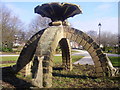
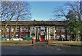
Rockingham Arms Hotel
Historic hotel on the old Great North Road in Doncaster http://www.rockinghamarmshotel.co.uk/
Image: © Richard Croft
Taken: 10 Jun 2008
0.23 miles
6
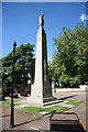
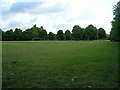
War Memorial
War memorial on Bennetthorpe Road
Image: © Richard Croft
Taken: 10 Jun 2008
0.24 miles
8
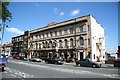
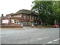
Mary Woollett Centre, Doncaster
The Mary Woollett Professional Development Centre is a fully equipped meeting and training venue situated just outside the centre of Doncaster. It operates under the aegis of Doncaster Council.
Image: © Neil Theasby
Taken: 9 Feb 2020
0.24 miles