IMAGES TAKEN NEAR TO
Station Road, GRIMSBY, DN41 7LX
Introduction
This page details the photographs taken nearby to Station Road, DN41 7LX by members of the Geograph project.
The Geograph project started in 2005 with the aim of publishing, organising and preserving representative images for every square kilometre of Great Britain, Ireland and the Isle of Man.

There are currently over 7.5m images from over14,400 individuals and you can help contribute to the project by visiting https://www.geograph.org.uk
Image Map
Images are licensed for reuse under creativecommons.org/licenses/by-sa/2.0
Notes
- Clicking on the map will re-center to the selected point.
- The higher the marker number, the further away the image location is from the centre of the postcode.
Image Listing (21 Images Found)
Images are licensed for reuse under creativecommons.org/licenses/by-sa/2.0
Image
Details
Distance
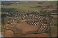
3
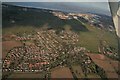
Healing: aerial 2018 (2)
Grimsby Dock Tower top right.
Image: © Chris
Taken: 25 Mar 2018
0.04 miles
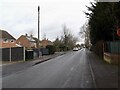
6
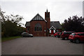
Healing Methodist Church
On Station Road, Healing.
Image: © Ian S
Taken: 20 Sep 2017
0.07 miles
7
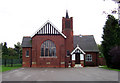
Healing Methodist Church
Healing Methodist Church, Healing, North East Lincolnshire.
Image: © David Wright
Taken: 19 Oct 2005
0.09 miles
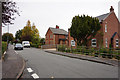
10
Healing & District Men's Social Club
On Rokkery Road, Healing.
Image: © Ian S
Taken: 20 Sep 2017
0.11 miles