IMAGES TAKEN NEAR TO
Brick Lane, IMMINGHAM, DN40 3PA
Introduction
This page details the photographs taken nearby to Brick Lane, DN40 3PA by members of the Geograph project.
The Geograph project started in 2005 with the aim of publishing, organising and preserving representative images for every square kilometre of Great Britain, Ireland and the Isle of Man.

There are currently over 7.5m images from over14,400 individuals and you can help contribute to the project by visiting https://www.geograph.org.uk
Image Map
Images are licensed for reuse under creativecommons.org/licenses/by-sa/2.0
Notes
- Clicking on the map will re-center to the selected point.
- The higher the marker number, the further away the image location is from the centre of the postcode.
Image Listing (12 Images Found)
Images are licensed for reuse under creativecommons.org/licenses/by-sa/2.0
Image
Details
Distance
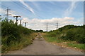
1
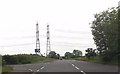
East Halton Road towards power lines
From Chase Hill Road junction on left
Image: © John Firth
Taken: 10 Jun 2013
0.17 miles
3
Scrub Lane
The tarmac ends just behind me and from now on Scrub lane is a track.
Image: © Jonathan Thacker
Taken: 24 Jul 2011
0.20 miles
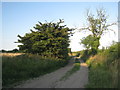
4
Scrub Lane, East Halton
Picture taken looking approx. East.
Image: © David Wright
Taken: 6 May 2006
0.21 miles
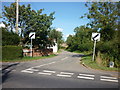
5
Byway extension of Eastfield Road, towards East Halton
Image: © Chris
Taken: 21 Jul 2016
0.22 miles
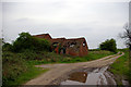
6
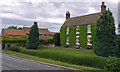
Baysgarth Farm, East Halton
A very green building.
Image: © David Wright
Taken: 18 Jul 2009
0.22 miles
7
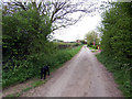
Scrub Lane, East Halton
Picture taken looking approx. West. The dog was friendly.
Image: © David Wright
Taken: 6 May 2006
0.23 miles

9
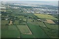
Cross East Halton Road, North Killingholme: aerial 2022
Image: © Chris
Taken: 15 Jun 2022
0.24 miles
10
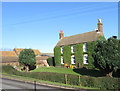
Baysgarth Farm, East Halton
Farmhouse facing on to Townside to the south of the village
Image: © Paul Harrop
Taken: 18 Feb 2016
0.24 miles