IMAGES TAKEN NEAR TO
North Killingholme, IMMINGHAM, DN40 3JX
Introduction
This page details the photographs taken nearby to DN40 3JX by members of the Geograph project.
The Geograph project started in 2005 with the aim of publishing, organising and preserving representative images for every square kilometre of Great Britain, Ireland and the Isle of Man.

There are currently over 7.5m images from over14,400 individuals and you can help contribute to the project by visiting https://www.geograph.org.uk
Image Map (Loading...)


Getting Data...Please wait
Leaflet Map data © OpenStreetMap
Images are licensed for reuse under creativecommons.org/licenses/by-sa/2.0
Notes
- Clicking on the map will re-center to the selected point.
- The higher the marker number, the further away the image location is from the centre of the postcode.
Image Listing (26 Images Found)
Images are licensed for reuse under creativecommons.org/licenses/by-sa/2.0
Image
Details
Distance
1
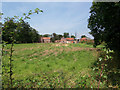
North Killingholme - Manor House and Manor Farm
The Manor House Image on the left of the picture is a Grade II* listed building. To the right is Manor Farm Image
Image: © David Wright
Taken: 10 Aug 2007
0.01 miles
2
Manor Farm, North Killingholme
North Killingholme Manor House (Tudor origin, listed) Image is situated adjacent to the farm.
Image: © David Wright
Taken: 10 Aug 2007
0.01 miles
3
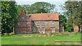
North Killingholme Manor House
Pevsner says "MANOR HOUSE. Decaying, and uncomfortably close to a vast oil refinery. On a partly moated site. The E wing probably Tudor, the relatively intact W wing c17. In the S front of the E wing three shields set in panels separated by little brick shafts. Each panel has a trefoil-cusped brick top - like the trefoil-cusping of the late c15 brick friezes in East Anglia..". This listed building is classified as being "At Risk".
Image: © David Wright
Taken: 10 Aug 2007
0.03 miles
4
Near Manor Farm, North Killingholme
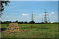
The storage tanks just visible on the right hand horizon are located in the refinery about 500m away on East Field Road.
Image: © David Wright
Taken: 10 Aug 2007
0.10 miles
5
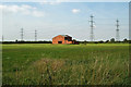
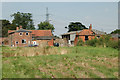
Ex-RAF Building
I strongly suspect that this isolated building formed part of nearby RAF North Killingholme, possibly used for handling explosives.
Image: © David Wright
Taken: 10 Aug 2007
0.15 miles
6
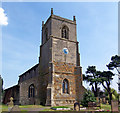
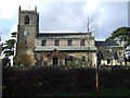
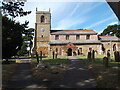
The Church Tower - North Killingholme
Tower of the church of St. Denys, North Killingholme.
Image: © David Wright
Taken: 10 Aug 2007
0.18 miles
7
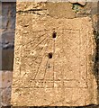
Church sundial
Incised sundial on St.Denys' church, probably 17th century
Image: © Richard Croft
Taken: 10 Apr 2009
0.19 miles
9
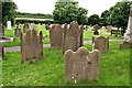
Meaningful messages on 19th century gravestones at North Killingholme
Image: © Chris
Taken: 21 Jul 2016
0.20 miles