IMAGES TAKEN NEAR TO
Hawkins Way, IMMINGHAM, DN40 3HQ
Introduction
This page details the photographs taken nearby to Hawkins Way, DN40 3HQ by members of the Geograph project.
The Geograph project started in 2005 with the aim of publishing, organising and preserving representative images for every square kilometre of Great Britain, Ireland and the Isle of Man.

There are currently over 7.5m images from over14,400 individuals and you can help contribute to the project by visiting https://www.geograph.org.uk
Image Map
Images are licensed for reuse under creativecommons.org/licenses/by-sa/2.0
Notes
- Clicking on the map will re-center to the selected point.
- The higher the marker number, the further away the image location is from the centre of the postcode.
Image Listing (17 Images Found)
Images are licensed for reuse under creativecommons.org/licenses/by-sa/2.0
Image
Details
Distance
1
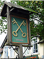
The Sign of the Cross Keys, South Killingholme
The Cross Keys Image] is situated on Top Road.
Image: © David Wright
Taken: 18 Jul 2009
0.05 miles
2
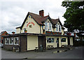
The Cross Keys, South Killingholme
The Cross Keys is situated on Top Road. A report in the "Scunthorpe Telegraph" on 19th June 2015 stated that the pub had ceased trading in 2012 and is now slated for demolition. It will be replaced by twelve new homes.
Image: © David Wright
Taken: 18 Jul 2009
0.06 miles
3
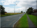
Top Road, South Killingholme
Photo taken from a position close to the Cross Keys public house looking towards East Halton.
Image: © David Wright
Taken: 18 Jul 2009
0.07 miles
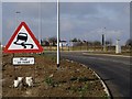
4
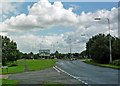
Roundabout at South Killingholme
Straight on for Habrough (minor road), right for Scunthorpe (A160), left for Immingham (A160).
Image: © David Wright
Taken: 18 Jul 2009
0.09 miles
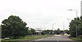
6
Approaching A160 roundabout
From Habrough Road
Image: © John Firth
Taken: 14 Jun 2013
0.11 miles
7

New road into South Killingholme
The old road, Top Road, runs across the front of the houses.
Image: © Chris
Taken: 21 Jul 2016
0.12 miles
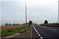
8
Roadworks near South Killingholme
The A160 improvement works have here involved relocating Habrough roundabout to the west of its former position, with new link roads from the A160 to Ulceby Road, Top Road and Habrough Road. This shot shows the new stretch of road linking Habrough Road with the new roundabout (off to the left).
Image: © Paul Harrop
Taken: 19 Feb 2017
0.19 miles
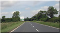
9
Near South Killingholme
Looking approx. NE along the A160 towards the roundabout which marks the junction with Top Road (left) and Habrough Road (right).
Image: © David Wright
Taken: 15 Oct 2005
0.19 miles
10

Traditional farm buildings in South Killingholme
Image: © Chris
Taken: 21 Jul 2016
0.20 miles