IMAGES TAKEN NEAR TO
St. Denys Close, IMMINGHAM, DN40 3EX
Introduction
This page details the photographs taken nearby to St. Denys Close, DN40 3EX by members of the Geograph project.
The Geograph project started in 2005 with the aim of publishing, organising and preserving representative images for every square kilometre of Great Britain, Ireland and the Isle of Man.

There are currently over 7.5m images from over14,400 individuals and you can help contribute to the project by visiting https://www.geograph.org.uk
Image Map
Images are licensed for reuse under creativecommons.org/licenses/by-sa/2.0
Notes
- Clicking on the map will re-center to the selected point.
- The higher the marker number, the further away the image location is from the centre of the postcode.
Image Listing (5 Images Found)
Images are licensed for reuse under creativecommons.org/licenses/by-sa/2.0
Image
Details
Distance
1
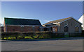
South Killingholme Methodist Church
Methodist Church at South Killingholme, North East Lincolnshire.
Image: © David Wright
Taken: 21 Jan 2006
0.21 miles
2
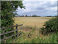
Agriculture and Industry near South Killingholme
Looking across a field of ripening Wheat towards the refinery.
Image: © David Wright
Taken: 18 Jul 2009
0.21 miles
3
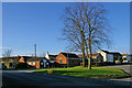
South Killingholme
The Methodist church is on the far side of the small green.
Image: © David Wright
Taken: 21 Jan 2006
0.22 miles
4
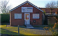
SB Hairdressing, South Killingholme
Small shop in South Killingholme.
Image: © David Wright
Taken: 21 Jan 2006
0.22 miles
5

Traditional farm buildings in South Killingholme
Image: © Chris
Taken: 21 Jul 2016
0.22 miles