IMAGES TAKEN NEAR TO
East End, ULCEBY, DN39 6YS
Introduction
This page details the photographs taken nearby to East End, DN39 6YS by members of the Geograph project.
The Geograph project started in 2005 with the aim of publishing, organising and preserving representative images for every square kilometre of Great Britain, Ireland and the Isle of Man.

There are currently over 7.5m images from over14,400 individuals and you can help contribute to the project by visiting https://www.geograph.org.uk
Image Map
Images are licensed for reuse under creativecommons.org/licenses/by-sa/2.0
Notes
- Clicking on the map will re-center to the selected point.
- The higher the marker number, the further away the image location is from the centre of the postcode.
Image Listing (89 Images Found)
Images are licensed for reuse under creativecommons.org/licenses/by-sa/2.0
Image
Details
Distance
1
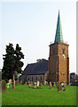
Church of St. Helen, Kirmington
The tower is described in Pevsner as "of very weathered ironstone" and this is apparent in the picture. The copper spire dates from 1838.
Image: © David Wright
Taken: 15 Oct 2005
0.05 miles
2
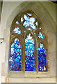
Kirmington - Aircrew Memorial Window
Stained glass war memorial window in the church of St. Helen, Kirmington. Squadron badges are incorporated in the lower right hand pane. RAF Kirmington is now Humberside International Airport.
Image: © David Wright
Taken: 15 Oct 2005
0.05 miles
3
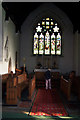
St. Helen, Kirmington
Interior picture of St. Helen, Kirmington. I was lucky to find the church open on a Saturday afternoon but a lady was doing the flowers for the Sunday service so I managed to some inside pictures in addition to the usual exterior shots.
Image: © David Wright
Taken: 15 Oct 2005
0.05 miles
4

Kirmington - Baptismal Font
Baptismal font in the church of St. Helen, Kirmington.
Image: © David Wright
Taken: 15 Oct 2005
0.05 miles
5
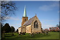
St.Helen's church, Kirmington, Lincs.
Early English tower, a 14th century arcade and the rest mostly by S.S.Teulon in 1859
Image: © Richard Croft
Taken: 29 Mar 2006
0.05 miles
6
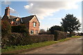
East End, Kirmington: estate house
On the corner of Post Office Lane.
Image: © Chris
Taken: 30 Mar 2013
0.05 miles
7
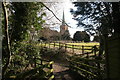
Footpath from the A18 to St. Helen's Church
Bridge over the beck.
Image: © Chris
Taken: 30 Mar 2013
0.07 miles
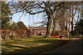
10
Footpath through St Helen's churchyard to the A18
Image: © Chris
Taken: 30 Mar 2013
0.10 miles