IMAGES TAKEN NEAR TO
Fortyfoot Lane, ULCEBY, DN39 6YJ
Introduction
This page details the photographs taken nearby to Fortyfoot Lane, DN39 6YJ by members of the Geograph project.
The Geograph project started in 2005 with the aim of publishing, organising and preserving representative images for every square kilometre of Great Britain, Ireland and the Isle of Man.

There are currently over 7.5m images from over14,400 individuals and you can help contribute to the project by visiting https://www.geograph.org.uk
Image Map (Loading...)


Getting Data...Please wait
Leaflet Map data © OpenStreetMap
Images are licensed for reuse under creativecommons.org/licenses/by-sa/2.0
Notes
- Clicking on the map will re-center to the selected point.
- The higher the marker number, the further away the image location is from the centre of the postcode.
Image Listing (43 Images Found)
Images are licensed for reuse under creativecommons.org/licenses/by-sa/2.0
Image
Details
Distance
2
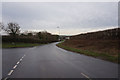
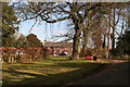
Public Footpath towards Melton Ross
The works at Melton Ross quarry are visible in the distance.
Image: © David Wright
Taken: 10 Dec 2009
0.14 miles

9

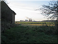
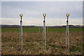
Humberside International Airport
Runway approach lights to Humberside International Airport, looking south-southwest from the footpath between Melton Ross Quarries and Croxton Road, Kirmington.
Image: © Paul Glazzard
Taken: 16 Jul 2008
0.18 miles
10
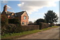
East End, Kirmington: estate house
On the corner of Post Office Lane.
Image: © Chris
Taken: 30 Mar 2013
0.18 miles