IMAGES TAKEN NEAR TO
Stephen Close, ULCEBY, DN39 6SP
Introduction
This page details the photographs taken nearby to Stephen Close, DN39 6SP by members of the Geograph project.
The Geograph project started in 2005 with the aim of publishing, organising and preserving representative images for every square kilometre of Great Britain, Ireland and the Isle of Man.

There are currently over 7.5m images from over14,400 individuals and you can help contribute to the project by visiting https://www.geograph.org.uk
Image Map
Images are licensed for reuse under creativecommons.org/licenses/by-sa/2.0
Notes
- Clicking on the map will re-center to the selected point.
- The higher the marker number, the further away the image location is from the centre of the postcode.
Image Listing (89 Images Found)
Images are licensed for reuse under creativecommons.org/licenses/by-sa/2.0
Image
Details
Distance
2
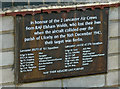
Plaque at Ulceby War Memorial
This plaque is situated on a wall immediately adjacent to Ulceby War Memorial Image There is also a memorial at Elsham Wolds dedicated to 103 and 576 Squadrons RAF Image
Image: © David Wright
Taken: 12 May 2007
0.01 miles
3
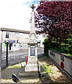
Ulceby War Memorial
The plaque on the wall to the right is a memorial to the crews of two Lancasters from Elsham Wolds lost in a collision over the parish on 16th December 1943 Image
Image: © David Wright
Taken: 12 May 2007
0.02 miles
4
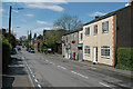
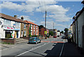
Ulceby High Street
View looking West along the High Street (A1077) with the Post Office on the right of the picture.
Image: © David Wright
Taken: 12 May 2007
0.03 miles
5
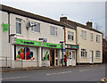
Ulceby village store and post office
This building on the corner of Abbey Road and Spruce Lane has undergone several facelifts even in the last few Geograph years!
See the Frith image from the 1960's which is how I remember it when I lived in the village as a child; http://www.francisfrith.com/ulceby,lincolnshire/photos/post-office-corner-c1960_U41021/
Also in 2005 and 2007; Image, Image
Image: © Jonathan Billinger
Taken: 29 Jul 2009
0.03 miles
6
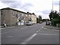
High Street, Ulceby
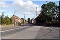
As seen from the junction with B1211, view looking eastwards.
Image: © John Beal
Taken: 15 Sep 2007
0.03 miles
7
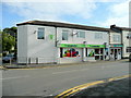
Ulceby Co-operative Store and Post Office
Ulceby Co-op has been modernised and enlarged since my last picture in 2005 Image
Image: © David Wright
Taken: 18 Jan 2010
0.04 miles
8
Ulceby
Picture taken from outside the "Brocklesby Ox" looking East along the main road in the direction of South Killingholme.
Image: © David Wright
Taken: 24 Sep 2005
0.04 miles
9
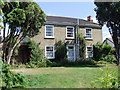
Ashtree House, Front Street, Ulceby
Grade II listed building http://www.britishlistedbuildings.co.uk/en-165896-ashtree-house-ulceby
Image: © David Wright
Taken: 10 Aug 2010
0.04 miles