IMAGES TAKEN NEAR TO
Oaktree Grove, ULCEBY, DN39 6AL
Introduction
This page details the photographs taken nearby to Oaktree Grove, DN39 6AL by members of the Geograph project.
The Geograph project started in 2005 with the aim of publishing, organising and preserving representative images for every square kilometre of Great Britain, Ireland and the Isle of Man.

There are currently over 7.5m images from over14,400 individuals and you can help contribute to the project by visiting https://www.geograph.org.uk
Image Map (Loading...)


Getting Data...Please wait
Leaflet Map data © OpenStreetMap
Images are licensed for reuse under creativecommons.org/licenses/by-sa/2.0
Notes
- Clicking on the map will re-center to the selected point.
- The higher the marker number, the further away the image location is from the centre of the postcode.
Image Listing (86 Images Found)
Images are licensed for reuse under creativecommons.org/licenses/by-sa/2.0
Image
Details
Distance
1
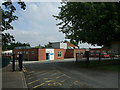
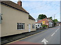
Ulceby Health Centre
The Health Centre shares this site with St. Nicholas' C of E primary school.
Image: © David Wright
Taken: 6 Aug 2009
0.02 miles
2
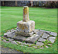
Base of Old Cross, Ulceby
Remnants of old cross in the churchyard of St. Nicholas, Ulceby.
Image: © David Wright
Taken: 3 Apr 2010
0.03 miles
3
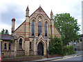
Ulceby Primitive Methodist Chapel
The facade carries a date of 1889. Relatively late and unrestrained for a Methodist Chapel in yellow and red brick with spirelets. Methodism must have been strong in this area - see Image for another Ulceby Chapel.
Image: © David Wright
Taken: 8 Jul 2006
0.03 miles
4
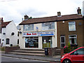
Sun Lee Ulceby Chippy
A surprising number of North Lincolnshire villages manage to support a Chinese takeaway. See Image for a nearby example.
Image: © David Wright
Taken: 8 Jul 2006
0.03 miles
5
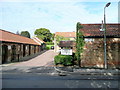
Yarborough Court, Ulceby
A converted barn complex on Front Street which includes a Veterinery Clinic.
Image: © Jonathan Billinger
Taken: 29 Jul 2009
0.04 miles
6
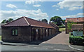
Yarborough Court Business Centre, Ulceby
Small business development off Front Street.
Image: © David Wright
Taken: 10 Aug 2010
0.05 miles
7
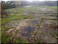
Site of the old primary school, 2
The opposite view to Image
Image: © Jonathan Billinger
Taken: 19 Dec 2002
0.05 miles
8
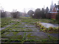
Site of the old primary school, 1
This photo was taken in 2002, seven years before my next visit Image
The concrete and tarmac playground is much clearer in this earlier shot.
The concrete on the right is the floor of the old cook house with the path to where the main school building stood leading diagonally towards the centre of shot. The main building is linked in the 2009 shot referred above, and we can see through to Manor House Farm.
Image: © Jonathan Billinger
Taken: 19 Dec 2002
0.05 miles
9
Ex-shop in Ulceby 3
A little further west up the High Street is this house which was known as the Top Shop when I lived in the village in the 1960's and 70's. It was always the best one for sweets!
Image: © Jonathan Billinger
Taken: 29 Jul 2009
0.05 miles
10
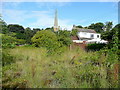
Patch of waste ground 1
This is the site of the old C of E Primary School for Ulceby, looking towards the spire of St. Nicholas' church.
See the old Frith image; http://www.francisfrith.com/ulceby,lincolnshire/photos/the-school-1965_U41017/
I am standing in the middle of what was the playground when I attended this school in 1968-70.
It is very surprising that this area has not been developed for housing during the past nearly 30 years!
Image: © Jonathan Billinger
Taken: 29 Jul 2009
0.05 miles