IMAGES TAKEN NEAR TO
Silver Street, BARNETBY, DN38 6HS
Introduction
This page details the photographs taken nearby to Silver Street, DN38 6HS by members of the Geograph project.
The Geograph project started in 2005 with the aim of publishing, organising and preserving representative images for every square kilometre of Great Britain, Ireland and the Isle of Man.

There are currently over 7.5m images from over14,400 individuals and you can help contribute to the project by visiting https://www.geograph.org.uk
Image Map
Images are licensed for reuse under creativecommons.org/licenses/by-sa/2.0
Notes
- Clicking on the map will re-center to the selected point.
- The higher the marker number, the further away the image location is from the centre of the postcode.
Image Listing (120 Images Found)
Images are licensed for reuse under creativecommons.org/licenses/by-sa/2.0
Image
Details
Distance
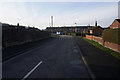
2
Viking Way off St Mary's Avenue, Barnetby-le-Wold
Image: © Ian S
Taken: 7 Mar 2018
0.07 miles
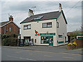
3
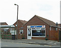
A'Salt 'N' Battery
Chippy in Barnetby which also has a Chinese take-away Image
Image: © David Wright
Taken: 3 May 2008
0.07 miles
6
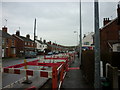
New lamps for old
New lampposts being fitted on Victoria Road, Barnetby le Wold.
Image: © Ian S
Taken: 24 Feb 2011
0.09 miles
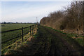
9

Victoria Road in Barnetby le Wold
Looking eastward.
Image: © Peter Wood
Taken: 23 Feb 2019
0.11 miles
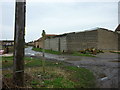
10
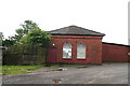
Old industrial building next to the railway, off Victoria Street
Said to be an old fish house.
Image: © Chris
Taken: 24 May 2014
0.11 miles