IMAGES TAKEN NEAR TO
Melton Ross, BARNETBY, DN38 6DR
Introduction
This page details the photographs taken nearby to DN38 6DR by members of the Geograph project.
The Geograph project started in 2005 with the aim of publishing, organising and preserving representative images for every square kilometre of Great Britain, Ireland and the Isle of Man.

There are currently over 7.5m images from over14,400 individuals and you can help contribute to the project by visiting https://www.geograph.org.uk
Image Map (83 Images)
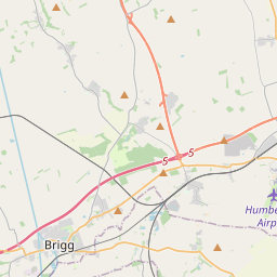

Leaflet Map data © OpenStreetMap
Images are licensed for reuse under creativecommons.org/licenses/by-sa/2.0
Notes
- Clicking on the map will re-center to the selected point.
- The higher the marker number, the further away the image location is from the centre of the postcode.
Image Listing (83 Images Found)
Images are licensed for reuse under creativecommons.org/licenses/by-sa/2.0
Image
Details
Distance
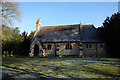
1
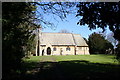
Church of the Ascension, Melton Ross, Lincs.
By Ewan Christian in 1867
Image: © Richard Croft
Taken: 29 Mar 2006
0.04 miles

5
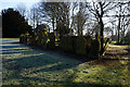
Gravestones at Church of the Holy Ascension, Melton Ross
Image: © Ian S
Taken: 21 Mar 2018
0.07 miles
6
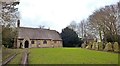
Church of the Ascension, Melton Ross
Built in 1867 it replaces an earlier church destroyed by fire
Image: © Chris Morgan
Taken: 6 Feb 2018
0.07 miles
9

The Church of the Ascension at Melton Ross
Viewed from the south-west.
Image: © Peter Wood
Taken: 23 Feb 2019
0.07 miles