IMAGES TAKEN NEAR TO
Owmby, BARNETBY, DN38 6AY
Introduction
This page details the photographs taken nearby to DN38 6AY by members of the Geograph project.
The Geograph project started in 2005 with the aim of publishing, organising and preserving representative images for every square kilometre of Great Britain, Ireland and the Isle of Man.

There are currently over 7.5m images from over14,400 individuals and you can help contribute to the project by visiting https://www.geograph.org.uk
Image Map
Images are licensed for reuse under creativecommons.org/licenses/by-sa/2.0
Notes
- Clicking on the map will re-center to the selected point.
- The higher the marker number, the further away the image location is from the centre of the postcode.
Image Listing (15 Images Found)
Images are licensed for reuse under creativecommons.org/licenses/by-sa/2.0
Image
Details
Distance
2
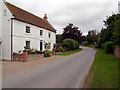
Owmby
Picture taken looking up Owmby Hill. The junction signed to the left is the road to Searby. The cottage is called Tithe House.
Image: © David Wright
Taken: 26 Jun 2006
0.01 miles
4

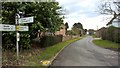
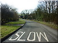
Station Lane in Owmby
Looking north-eastward.
Image: © Peter Wood
Taken: 23 Feb 2019
0.03 miles
6
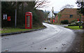
Information highway: Owmby
Village noticeboard, post box and telephone box
Image: © Kate Nicol
Taken: 11 Jan 2009
0.07 miles
7
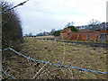
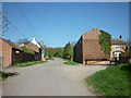
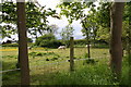
Crew Yard and pasture
This just makes it into this square. These yards, a once familiar sight, are not often now seen in use in this area.
Image: © Kate Nicol
Taken: 11 Jan 2009
0.07 miles
8
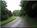
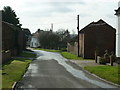
Looking down Owmby Hill towards Owmby
From the point where the Viking Way crosses the road
Image: © Tim Heaton
Taken: 3 Jun 2008
0.09 miles
10
Shetland Ponies grazing by the bend out of Owmby
Image: © Chris
Taken: 24 May 2014
0.11 miles